IMAGES TAKEN NEAR TO
French Street, WIDNES, WA8 0BT
Introduction
This page details the photographs taken nearby to French Street, WA8 0BT by members of the Geograph project.
The Geograph project started in 2005 with the aim of publishing, organising and preserving representative images for every square kilometre of Great Britain, Ireland and the Isle of Man.

There are currently over 7.5m images from over14,400 individuals and you can help contribute to the project by visiting https://www.geograph.org.uk
Image Map
Images are licensed for reuse under creativecommons.org/licenses/by-sa/2.0
Notes
- Clicking on the map will re-center to the selected point.
- The higher the marker number, the further away the image location is from the centre of the postcode.
Image Listing (6 Images Found)
Images are licensed for reuse under creativecommons.org/licenses/by-sa/2.0
Image
Details
Distance
2
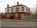
The Commercial Hotel
Derelict public house on Page Lane at Widnes.
Image: © David Dixon
Taken: 23 Apr 2013
0.23 miles
3
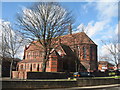
St Ambrose, Halton View
The church of St Ambrose (Church of England) is situated at the junction of Halton View Road with Warrington Road and was consecrated in 1883. It was designed by James Francis Doyle of Liverpool and was originally designed to have a tower and spire which were never completed.
Image: © Sue Adair
Taken: 7 Mar 2008
0.23 miles
4
Page Lane, Commercial Hotel
Derelict, boarded-up public house on Page lane at Widnes.
Image: © David Dixon
Taken: 23 Apr 2013
0.23 miles
5
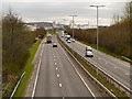
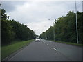
Watkinson Way (A557)
Looking south from the footbridge at Page Lane.
Image: © David Dixon
Taken: 23 Apr 2013
0.24 miles
6
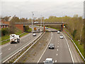
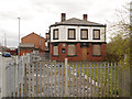
Widnes, Watkinson Way
Looking northwards from the footbridge at Page Lane.
Image: © David Dixon
Taken: 23 Apr 2013
0.25 miles