IMAGES TAKEN NEAR TO
Allendale, RUNCORN, WA7 6PR
Introduction
This page details the photographs taken nearby to Allendale, WA7 6PR by members of the Geograph project.
The Geograph project started in 2005 with the aim of publishing, organising and preserving representative images for every square kilometre of Great Britain, Ireland and the Isle of Man.

There are currently over 7.5m images from over14,400 individuals and you can help contribute to the project by visiting https://www.geograph.org.uk
Image Map
Images are licensed for reuse under creativecommons.org/licenses/by-sa/2.0
Notes
- Clicking on the map will re-center to the selected point.
- The higher the marker number, the further away the image location is from the centre of the postcode.
Image Listing (5 Images Found)
Images are licensed for reuse under creativecommons.org/licenses/by-sa/2.0
Image
Details
Distance
1
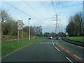
Palace Fields Road
By the junctions of Allendale on the left and Wren Close on the right
Image: © Maggie Cox
Taken: 14 Nov 2013
0.08 miles
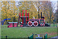
3
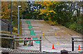
Runcorn Ski and Snowboard centre
It must be too cold for skiing (or the wrong kind of leaves?)
Image: © Ian Greig
Taken: 26 Oct 2012
0.18 miles