IMAGES TAKEN NEAR TO
Blyth Close, RUNCORN, WA7 6DN
Introduction
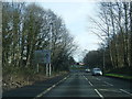
This page details the photographs taken nearby to Blyth Close, WA7 6DN by members of the Geograph project.
The Geograph project started in 2005 with the aim of publishing, organising and preserving representative images for every square kilometre of Great Britain, Ireland and the Isle of Man.

There are currently over 7.5m images from over14,400 individuals and you can help contribute to the project by visiting https://www.geograph.org.uk
Image Map
Images are licensed for reuse under creativecommons.org/licenses/by-sa/2.0
Notes
- Clicking on the map will re-center to the selected point.
- The higher the marker number, the further away the image location is from the centre of the postcode.
Image Listing (3 Images Found)
Images are licensed for reuse under creativecommons.org/licenses/by-sa/2.0
Image
Details
Distance
1
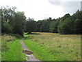
Murdishaw Wood
Track through Murdishaw Wood linking the estate of Murdishaw, by footbridge over the M56, with Sandy Lane, Preston Brook.
Image: © Sue Adair
Taken: 4 Aug 2010
0.17 miles