IMAGES TAKEN NEAR TO
Norman Road, RUNCORN, WA7 5PQ
Introduction
This page details the photographs taken nearby to Norman Road, WA7 5PQ by members of the Geograph project.
The Geograph project started in 2005 with the aim of publishing, organising and preserving representative images for every square kilometre of Great Britain, Ireland and the Isle of Man.

There are currently over 7.5m images from over14,400 individuals and you can help contribute to the project by visiting https://www.geograph.org.uk
Image Map
Images are licensed for reuse under creativecommons.org/licenses/by-sa/2.0
Notes
- Clicking on the map will re-center to the selected point.
- The higher the marker number, the further away the image location is from the centre of the postcode.
Image Listing (8 Images Found)
Images are licensed for reuse under creativecommons.org/licenses/by-sa/2.0
Image
Details
Distance
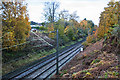
1
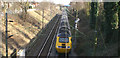
Next stop Runcorn
The London - Liverpool main line at Runcorn
Image: © David Long
Taken: 22 Mar 2006
0.16 miles
2
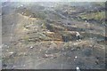
Slope stabilization, cutting, Higher Runcorn
Image: © N Chadwick
Taken: 21 Mar 2016
0.19 miles
3
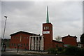
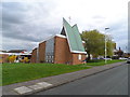
St Edwards RC Church and Parish Centre, Runcorn
Image: © Alexander P Kapp
Taken: 27 Jan 2006
0.21 miles
5
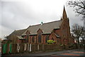
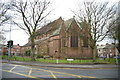
St John's Presbyterian Church, Runcorn
Image: © Alexander P Kapp
Taken: 27 Jan 2006
0.23 miles