IMAGES TAKEN NEAR TO
Percival Lane, RUNCORN, WA7 4XE
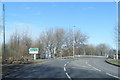
Introduction
This page details the photographs taken nearby to Percival Lane, WA7 4XE by members of the Geograph project.
The Geograph project started in 2005 with the aim of publishing, organising and preserving representative images for every square kilometre of Great Britain, Ireland and the Isle of Man.

There are currently over 7.5m images from over14,400 individuals and you can help contribute to the project by visiting https://www.geograph.org.uk
Image Map
Images are licensed for reuse under creativecommons.org/licenses/by-sa/2.0
Notes
- Clicking on the map will re-center to the selected point.
- The higher the marker number, the further away the image location is from the centre of the postcode.
Image Listing (18 Images Found)
Images are licensed for reuse under creativecommons.org/licenses/by-sa/2.0
Image
Details
Distance
1
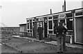
Cheshire Rambler Railtour ? Folly Lane
Folly Lane was the interchange point between the British Railways network and the Western Point industrial area, with significant chemicals traffic. The building is the BR operations office at the site, complete with 'station' name board. The then relatively recently opened (1961) Runcorn-Widnes road bridge can be seen in the distance.
Image: © Alan Murray-Rust
Taken: 27 Apr 1963
0.03 miles
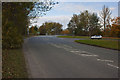
2
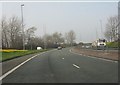
Weston Point Expressway curving north of Westfield junction
Image: © Peter Whatley
Taken: 23 Mar 2012
0.06 miles
3
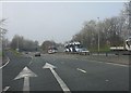
Westfield junction, Weston Point Expressway
Image: © Peter Whatley
Taken: 23 Mar 2012
0.14 miles
4
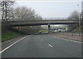
Weston Point Expressway - Westfield junction bridge
Image: © Peter Whatley
Taken: 23 Mar 2012
0.14 miles
6
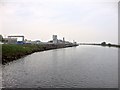
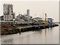
Manchester Ship Canal, Industrial Scene at Runcorn
Image: © David Dixon
Taken: 11 May 2016
0.17 miles
7
Approaching a bridge over the Runcorn expressway
Image: © Ian Greig
Taken: 26 Oct 2012
0.17 miles
8
Steps on the bank below Bridgewater lock
The lock is disused, and the steps may be too.
Image: © Christine Johnstone
Taken: 13 Apr 2013
0.18 miles
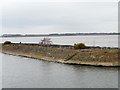
9
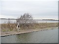
Manchester Ship Canal navigation beacon
On the north-west bank, west of Bridgewater lock.
Image: © Christine Johnstone
Taken: 13 Apr 2013
0.18 miles
10
Francis Flower Northern Minerals Recycling Plant at Runcorn
Image: © David Dixon
Taken: 11 May 2016
0.20 miles