IMAGES TAKEN NEAR TO
Lambsickle Lane, RUNCORN, WA7 4RA
Introduction
This page details the photographs taken nearby to Lambsickle Lane, WA7 4RA by members of the Geograph project.
The Geograph project started in 2005 with the aim of publishing, organising and preserving representative images for every square kilometre of Great Britain, Ireland and the Isle of Man.

There are currently over 7.5m images from over14,400 individuals and you can help contribute to the project by visiting https://www.geograph.org.uk
Image Map
Images are licensed for reuse under creativecommons.org/licenses/by-sa/2.0
Notes
- Clicking on the map will re-center to the selected point.
- The higher the marker number, the further away the image location is from the centre of the postcode.
Image Listing (13 Images Found)
Images are licensed for reuse under creativecommons.org/licenses/by-sa/2.0
Image
Details
Distance
1
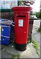
Elizabeth II postbox, Weston Village Stores
Postbox No. WA7 8.
See Image] for context.
Image: © JThomas
Taken: 25 Jul 2023
0.19 miles
2
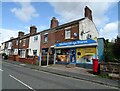
Weston Village Stores
Showing position of Postbox No. WA7 8.
See Image] for postbox.
Image: © JThomas
Taken: 25 Jul 2023
0.19 miles
4
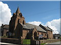
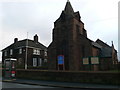
St John the Evangelist, Weston Village
St John the Evangelist, Weston Village was built in 1896-97 of red sandstone with a Welsh slate roof. To help fund its building, the choirboys wrote letters to other choirboys throughout England, asking for a small donation towards its construction. In gratitude, the initials of those Weston choirboys were carved on the church steeple.
Image: © Sue Adair
Taken: 9 Jul 2007
0.20 miles
6
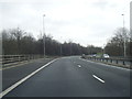
Weston Point Expressway - Rocksavage exit
Note the capitalisation for the Runcorn-Widnes bridge.
Image: © Peter Whatley
Taken: 23 Mar 2012
0.23 miles
8
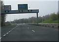
Weston Point Expressway - Rocksavage junction bridge
Image: © Peter Whatley
Taken: 23 Mar 2012
0.23 miles
9
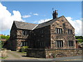
Cavendish Farm, Weston Village
Cavendish Farm, Weston Village was originally constructed in 1622 of local red sandstone.
Image: © Sue Adair
Taken: 9 Jul 2007
0.24 miles
10
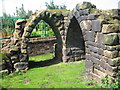
Ruins, Weston Village
Ruins of unknown origin, Bankes Lane, Weston Village.
Image: © Sue Adair
Taken: 9 Jul 2007
0.24 miles