IMAGES TAKEN NEAR TO
Park Road, RUNCORN, WA7 4PU
Introduction
This page details the photographs taken nearby to Park Road, WA7 4PU by members of the Geograph project.
The Geograph project started in 2005 with the aim of publishing, organising and preserving representative images for every square kilometre of Great Britain, Ireland and the Isle of Man.

There are currently over 7.5m images from over14,400 individuals and you can help contribute to the project by visiting https://www.geograph.org.uk
Image Map
Images are licensed for reuse under creativecommons.org/licenses/by-sa/2.0
Notes
- Clicking on the map will re-center to the selected point.
- The higher the marker number, the further away the image location is from the centre of the postcode.
Image Listing (6 Images Found)
Images are licensed for reuse under creativecommons.org/licenses/by-sa/2.0
Image
Details
Distance
3
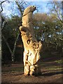
Carving, Runcorn Hill
A carving of local woodland animals by Angela Stillwell on Runcorn Hill.
Image: © Sue Adair
Taken: 6 Jan 2008
0.19 miles
4
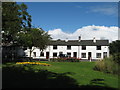
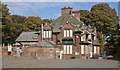
Quarry Workers Cottages, Highlands Road
Quarry Workers Cottages, Highlands Road, dating from the 1800's. The quarry extended right up to the front doors by 1860. Runcorn Hill visitor centre and recreation ground stand on top of 35,000 tonnes of quarry spoil which was used to backfill the quarry.
Image: © Sue Adair
Taken: 17 Sep 2007
0.20 miles