IMAGES TAKEN NEAR TO
Weston Road, RUNCORN, WA7 4LD
Introduction
This page details the photographs taken nearby to Weston Road, WA7 4LD by members of the Geograph project.
The Geograph project started in 2005 with the aim of publishing, organising and preserving representative images for every square kilometre of Great Britain, Ireland and the Isle of Man.

There are currently over 7.5m images from over14,400 individuals and you can help contribute to the project by visiting https://www.geograph.org.uk
Image Map
Images are licensed for reuse under creativecommons.org/licenses/by-sa/2.0
Notes
- Clicking on the map will re-center to the selected point.
- The higher the marker number, the further away the image location is from the centre of the postcode.
Image Listing (9 Images Found)
Images are licensed for reuse under creativecommons.org/licenses/by-sa/2.0
Image
Details
Distance
1
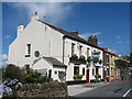
The Prospect Inn, Runcorn Hill
The Prospect Inn on Weston Road, situated on Runcorn Hill with great views of the Mersey, the Wirral and North Wales.
Image: © Sue Adair
Taken: 9 Jul 2007
0.03 miles
2
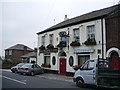
The Prospect Inn, 70 Weston Road, Runcorn
Image: © Alexander P Kapp
Taken: 9 Oct 2007
0.04 miles
3
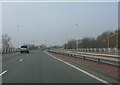
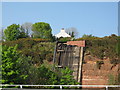
Weston Point Expressway - Weston junction bridge
Image: © Peter Whatley
Taken: 23 Mar 2012
0.15 miles
4

Weston Village Hall
There are a number of carved stones built into this wall, from buildings which no longer exist. Apparently it was found that gas was leaking from infill in an old quarry where they were situated, and they were demolished. The stones are presumably located where the buildings used to be. This one comes from the old village hall; it was built as a school in the 19th century but was out of use by 1902. At this point it was purchased by Sir John Brunner (of the Brunner-Mond chemical empire, late ICI) and given to the village as a village hall.
Image: © Alan Murray-Rust
Taken: 6 Oct 2008
0.18 miles
5
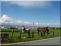
Ponies on Weston Road, Runcorn Hill
Ponies on Weston Road, Runcorn Hill with the chimneys ICI and the river Mersey in the background.
Image: © Sue Adair
Taken: 9 Jul 2007
0.18 miles
6

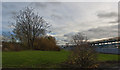
Weston Road
The area to the left was not always open fields. You can see a number of carved stones built into this wall, and these are from buildings which no longer exist. Apparently it was found that gas was leaking from infill in an old quarry where they were situated, and they were demolished. The stones are presumably located where the buildings used to be. One of them can be seen here Image
Image: © Alan Murray-Rust
Taken: 6 Oct 2008
0.21 miles
8
Runcorn Hill and Pipelines at Weston Point
Image: © Sue Adair
Taken: 3 May 2007
0.23 miles
9
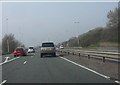
Weston Point Expressway - Weston exit
Image: © Peter Whatley
Taken: 23 Mar 2012
0.24 miles