IMAGES TAKEN NEAR TO
Portside, RUNCORN, WA7 3LE
Introduction
This page details the photographs taken nearby to Portside, WA7 3LE by members of the Geograph project.
The Geograph project started in 2005 with the aim of publishing, organising and preserving representative images for every square kilometre of Great Britain, Ireland and the Isle of Man.

There are currently over 7.5m images from over14,400 individuals and you can help contribute to the project by visiting https://www.geograph.org.uk
Image Map
Images are licensed for reuse under creativecommons.org/licenses/by-sa/2.0
Notes
- Clicking on the map will re-center to the selected point.
- The higher the marker number, the further away the image location is from the centre of the postcode.
Image Listing (16 Images Found)
Images are licensed for reuse under creativecommons.org/licenses/by-sa/2.0
Image
Details
Distance
2

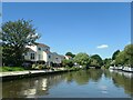
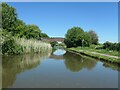
Bridgewater canal, between bridges 68 and 69
The houses are on Quay Place, but there was never a wharf here. On the Runcorn section of the Bridgewater canal. This was originally the main line of the canal, linking Manchester and Liverpool via the tidal Mersey at Runcorn.
Image: © Christine Johnstone
Taken: 30 May 2021
0.06 miles
3
Marina village, Bridgewater canal
On the Runcorn section of the Bridgewater canal. This was originally the main line of the canal, linking Manchester and Liverpool via the tidal Mersey at Runcorn.
Image: © Christine Johnstone
Taken: 30 May 2021
0.10 miles
5
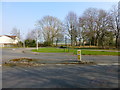
Cycleway sign on Falstone Drive
Burrow's bridge over the Bridgewater Canal seen in background
Image: © Raymond Knapman
Taken: 19 Mar 2015
0.15 miles
6
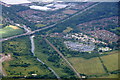
Preston Brook Marina, Runcorn from the air
Taken from a plane on the approach to Liverpool John Lennon Airport.
Image: © Mike Pennington
Taken: 5 Jul 2016
0.15 miles
7
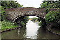
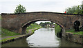
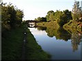
Borrow's Bridge [no 69], from the south
Carrying Red Brow Lane over the Runcorn section of the Bridgewater canal. This was originally the main line of the canal, linking Manchester and Liverpool via the tidal Mersey at Runcorn.
Image: © Christine Johnstone
Taken: 30 May 2021
0.15 miles
9
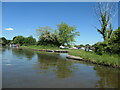
Entrance to Preston Brook marina
Discreet entrance for a fair-sized marina. On the north bank of the Runcorn section of the Bridgewater Canal.
Image: © Christine Johnstone
Taken: 30 May 2021
0.17 miles
10
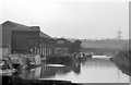
Norton Warehouses & narrow boats, Bridgewater Canal, from SE
View looking NW along the Bridgewater Canal showing Norton warehouses of which only the 2nd along survives, in front are moored working narrow boats of the Anderton Canal Carrying Company's fleet. At this time its canal carrying activities had more or less come to an end. The outermost of the 3 narrow boats is the 'Mountbatten' see http://hnbc.org.uk/boats/mountbatten & astern of it lies the butty 'Argo', see http://hnbc.org.uk/boats/argo Between the 1st & 2nd warehouses is Norton basin. In the immediate foreground the blurry outline of steel sheeting indicates engineering work & a temporary narrowing of the canal which allowed me to take this photo apparently from the middle of the canal. For a 2011 view from a similar point see Image In the distance is Cawley's Bridge, for my photo from there see: Image
Image: © Martin Tester
Taken: Unknown
0.21 miles