IMAGES TAKEN NEAR TO
Aston Fields Road, RUNCORN, WA7 3FZ
Introduction
This page details the photographs taken nearby to Aston Fields Road, WA7 3FZ by members of the Geograph project.
The Geograph project started in 2005 with the aim of publishing, organising and preserving representative images for every square kilometre of Great Britain, Ireland and the Isle of Man.

There are currently over 7.5m images from over14,400 individuals and you can help contribute to the project by visiting https://www.geograph.org.uk
Image Map
Images are licensed for reuse under creativecommons.org/licenses/by-sa/2.0
Notes
- Clicking on the map will re-center to the selected point.
- The higher the marker number, the further away the image location is from the centre of the postcode.
Image Listing (11 Images Found)
Images are licensed for reuse under creativecommons.org/licenses/by-sa/2.0
Image
Details
Distance
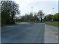
5
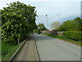
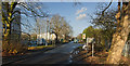
Aston Lane, Aston
As it approaches the railway bridge
Image: © Alexander P Kapp
Taken: 2 May 2012
0.18 miles
6
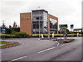
Whitehouse Roundabout , A56
The traffic island at the junction of the A56 (Chester Road) with the A533 (Northwich Road) at Preston Brook.
Image: © David Dixon
Taken: 5 Jun 2012
0.20 miles
7
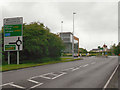
Chester Road, Whitehouse Roundabout
Approaching the Whitehouse Roundabout on the A56 (Chester Road)
Image: © David Dixon
Taken: 5 Jun 2012
0.22 miles
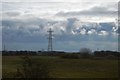
10
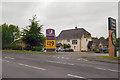
Preston Brook
The Preston Brook hotel and restaurant at the side of the A56.
Image: © David Dixon
Taken: 5 Jun 2012
0.24 miles