IMAGES TAKEN NEAR TO
Rose Mount, Gorsey Well Lane, RUNCORN, WA7 3AS
Introduction
This page details the photographs taken nearby to Rose Mount, Gorsey Well Lane, WA7 3AS by members of the Geograph project.
The Geograph project started in 2005 with the aim of publishing, organising and preserving representative images for every square kilometre of Great Britain, Ireland and the Isle of Man.

There are currently over 7.5m images from over14,400 individuals and you can help contribute to the project by visiting https://www.geograph.org.uk
Image Map
Images are licensed for reuse under creativecommons.org/licenses/by-sa/2.0
Notes
- Clicking on the map will re-center to the selected point.
- The higher the marker number, the further away the image location is from the centre of the postcode.
Image Listing (80 Images Found)
Images are licensed for reuse under creativecommons.org/licenses/by-sa/2.0
Image
Details
Distance
1

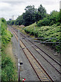
Railway line at Preston Brook, Cheshire
Looking north from Chester Road Bridge. This line runs between Crewe and Warrington. The bridge ahead carries the M56 motorway.
Some infestation with Japanese knotweed is visible on the right. Apparently this almost indestructible invasive plant can be destroyed (at last) by use of an insect (Aphalara itadori) which only eats knotweed. http://en.wikipedia.org/wiki/Japanese_knotweed
Image: © Roger D Kidd
Taken: 29 Aug 2011
0.06 miles
2

Bridgewater Canal, Preston Brook branch
Looking south towards Preston Brook Bridge, which carries the A56 over the canal. Some 200 yards further south, there is the (unmarked) end-on junction with the Trent and Mersey Canal.
Image: © Dr Neil Clifton
Taken: 24 Nov 2013
0.07 miles
3
Railway line at Preston Brook, Cheshire
Looking south from Chester Road Bridge. This line runs between Warrington and Crewe. Both sides are infested with Japanese knotweed. Apparently this almost indestructible invasive plant can be destroyed (at last) by use of an insect (Aphalara itadori) which only eats knotweed. http://en.wikipedia.org/wiki/Japanese_knotweed
Image: © Roger D Kidd
Taken: 29 Aug 2011
0.08 miles
4
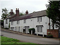
Row of cottages at Preston Brook, Cheshire
The Brook House cottages are on The Wharf by Preston Brook Bridge over the Bridgewater Canal. The row is Grade II listed, and built in the late 18th century in Gothic style. http://en.wikipedia.org/wiki/File:Preston_Brook_Brook_House.jpg
Image: © Roger D Kidd
Taken: 30 Aug 2011
0.08 miles
5

Brook House cottages at Preston Brook, Cheshire
The Brook House cottages are on The Wharf by Preston Brook Bridge over the Bridgewater Canal. The row is Grade II listed, and built in the late 18th century in Gothic style. http://en.wikipedia.org/wiki/File:Preston_Brook_Brook_House.jpg
Image: © Roger D Kidd
Taken: 29 Aug 2011
0.08 miles
6
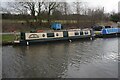
Preston Brook on the Bridgewater Canal
Image: © Raymond Knapman
Taken: 19 Mar 2015
0.08 miles
7
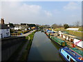
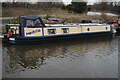
Bridgewater Canal: Preston Brook Bridge
Looking south. This bridge carries the A56. Some 200 yards further on, the canal becomes the Trent and Mersey Canal, and after some severe lockage (known to some as 'Heartbreak Hill') you can pass along the Middlewich Branch and reach the Shropshire Union. The boat in the photograph is 'Halton Castle' of the Claymoore Navigation Company.
Image: © Dr Neil Clifton
Taken: 24 Nov 2013
0.09 miles
10
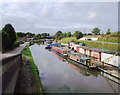
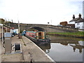
The Bridgewater Canal at Preston Brook, Cheshire
Looking north-north-west from Preston Brook Bridge (No 1), which carries the A56 Chester Road.
David Dixon writes:
Image: © Roger D Kidd
Taken: 29 Aug 2011
0.09 miles