IMAGES TAKEN NEAR TO
Maricopa Close, RUNCORN, WA7 2UU
Introduction
This page details the photographs taken nearby to Maricopa Close, WA7 2UU by members of the Geograph project.
The Geograph project started in 2005 with the aim of publishing, organising and preserving representative images for every square kilometre of Great Britain, Ireland and the Isle of Man.

There are currently over 7.5m images from over14,400 individuals and you can help contribute to the project by visiting https://www.geograph.org.uk
Image Map
Images are licensed for reuse under creativecommons.org/licenses/by-sa/2.0
Notes
- Clicking on the map will re-center to the selected point.
- The higher the marker number, the further away the image location is from the centre of the postcode.
Image Listing (10 Images Found)
Images are licensed for reuse under creativecommons.org/licenses/by-sa/2.0
Image
Details
Distance
1
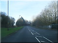
Castlefields Avenue East at Plantation Close
Image: © Colin Pyle
Taken: 30 Jan 2016
0.11 miles
2
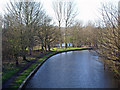
Bridgewater Canal
Bridgewater Canal from bridge south of Norton Priory. Castlefields Lake in the background.
Image: © Mike Harris
Taken: 14 Jan 2007
0.17 miles
3
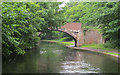
Green's Bridge 75
Bridgewater Canal - Runcorn Section
Image: © Mike Todd
Taken: 16 May 2011
0.17 miles
4
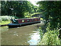
The Bridgewater Canal near Runcorn
This scene is taken from the grounds of Norton Priory Museum, Runcorn. If you walk to the bottom of the gardens, they end at the Bridgewater Canal. There are always plenty of narrowboats to be seen as they pass continuously.
Image: © Neil Kennedy
Taken: 29 Jun 2003
0.18 miles
5
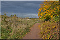
Leaves turning on the Bridgewater Way
The power station in the background is Fiddlers Ferry on the other side of the Mersey
Image: © Ian Greig
Taken: 26 Oct 2012
0.22 miles
6
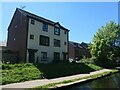
Canalside houses, Medlock Close, Castlefields
On the south bank of the Bridgewater canal.
Image: © Christine Johnstone
Taken: 30 May 2021
0.23 miles
7
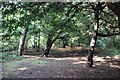
The Woodland at Norton Priory
The site of Norton Priory now comprises of the remains of an abbey complex dating from the 12th to 16th centuries, and an 18th century country house.
Wikipedia https://en.wikipedia.org/wiki/Norton_Priory
Image: © Jeff Buck
Taken: 14 Sep 2016
0.23 miles
8
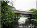
Busway Bridge 76
Bridgewater Canal - Runcorn Section
Image: © Mike Todd
Taken: 16 May 2011
0.23 miles
9
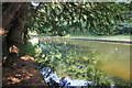
The Bridgewater Canal at Norton Priory
The Bridgewater Canal seen from the southern end of the woodland park at Norton Priory.
The site of Norton Priory now comprises of the remains of an abbey complex dating from the 12th to 16th centuries, and an 18th century country house.
Wikipedia https://en.wikipedia.org/wiki/Norton_Priory
Image: © Jeff Buck
Taken: 14 Sep 2016
0.24 miles
10
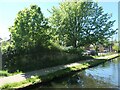
Low stone wall alongside the Bridgewater canal towpath
Near Medlock Close, between bridges 76 and 77. The large-scale OS map from the 1870s hints at an underbridge here, on the south side of Haltongate Farm, so perhaps this is the former bridge parapet.
Image: © Christine Johnstone
Taken: 30 May 2021
0.25 miles