IMAGES TAKEN NEAR TO
Greenbridge Close, RUNCORN, WA7 2LZ
Introduction
This page details the photographs taken nearby to Greenbridge Close, WA7 2LZ by members of the Geograph project.
The Geograph project started in 2005 with the aim of publishing, organising and preserving representative images for every square kilometre of Great Britain, Ireland and the Isle of Man.

There are currently over 7.5m images from over14,400 individuals and you can help contribute to the project by visiting https://www.geograph.org.uk
Image Map
Images are licensed for reuse under creativecommons.org/licenses/by-sa/2.0
Notes
- Clicking on the map will re-center to the selected point.
- The higher the marker number, the further away the image location is from the centre of the postcode.
Image Listing (9 Images Found)
Images are licensed for reuse under creativecommons.org/licenses/by-sa/2.0
Image
Details
Distance
1
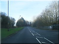
Castlefields Avenue East at Plantation Close
Image: © Colin Pyle
Taken: 30 Jan 2016
0.10 miles
2
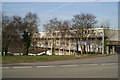
Great expectations
Housing on the Castlefields Estate in Runcorn New Town
Image: © David Long
Taken: 22 Mar 2006
0.21 miles
3
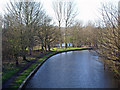
Bridgewater Canal
Bridgewater Canal from bridge south of Norton Priory. Castlefields Lake in the background.
Image: © Mike Harris
Taken: 14 Jan 2007
0.22 miles
4
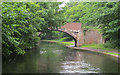
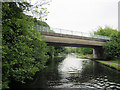
Green's Bridge 75
Bridgewater Canal - Runcorn Section
Image: © Mike Todd
Taken: 16 May 2011
0.23 miles
5
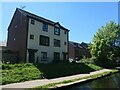
Canalside houses, Medlock Close, Castlefields
On the south bank of the Bridgewater canal.
Image: © Christine Johnstone
Taken: 30 May 2021
0.23 miles
6
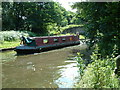
The Bridgewater Canal near Runcorn
This scene is taken from the grounds of Norton Priory Museum, Runcorn. If you walk to the bottom of the gardens, they end at the Bridgewater Canal. There are always plenty of narrowboats to be seen as they pass continuously.
Image: © Neil Kennedy
Taken: 29 Jun 2003
0.23 miles
7
Busway Bridge 76
Bridgewater Canal - Runcorn Section
Image: © Mike Todd
Taken: 16 May 2011
0.23 miles
8
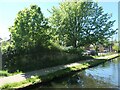
Low stone wall alongside the Bridgewater canal towpath
Near Medlock Close, between bridges 76 and 77. The large-scale OS map from the 1870s hints at an underbridge here, on the south side of Haltongate Farm, so perhaps this is the former bridge parapet.
Image: © Christine Johnstone
Taken: 30 May 2021
0.24 miles
9
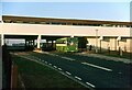
Runcorn busway, Castlefields ? 1971
The busway had opened in October of that year as the world's first rapid transit busway, operating on dedicated roadways.
This view is taken at one of the satellite suburban centres, Castlefields, showing the bus stop under cover of a high level walkway/parade. This building has since been demolished and the immediate area is now semi-pedestrianised. The section of busway behind the photographer is now available to local traffic as well as buses.
To operate services the local operator Crosville purchased a fleet of Seddon RU single-deck buses. This was a radical departure from their traditional vehicle policy which was almost exclusively of Bristol origin, but Seddons were able to supply a large number of the type at a time when other types were suffering considerable delays in delivery dates. Seen here is bus SPG783 (OFM783K), delivered in October 1971 for the opening of the busway.
This is one of a series of views featuring buses in the 60s, 70s, and 80s. http://www.geograph.org.uk/search.php?i=2114547&displayclass=slide
Image: © Alan Murray-Rust
Taken: 29 Dec 1971
0.25 miles