IMAGES TAKEN NEAR TO
Village Close, RUNCORN, WA7 2LJ
Introduction
This page details the photographs taken nearby to Village Close, WA7 2LJ by members of the Geograph project.
The Geograph project started in 2005 with the aim of publishing, organising and preserving representative images for every square kilometre of Great Britain, Ireland and the Isle of Man.

There are currently over 7.5m images from over14,400 individuals and you can help contribute to the project by visiting https://www.geograph.org.uk
Image Map
Images are licensed for reuse under creativecommons.org/licenses/by-sa/2.0
Notes
- Clicking on the map will re-center to the selected point.
- The higher the marker number, the further away the image location is from the centre of the postcode.
Image Listing (9 Images Found)
Images are licensed for reuse under creativecommons.org/licenses/by-sa/2.0
Image
Details
Distance
1
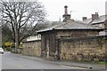
Main Street, Halton
A small sandstone building beside Main Street.
Image: © Richard Webb
Taken: 3 Apr 2015
0.06 miles
3
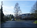
Norton Lane/Main Street junction at village boundary
Image: © Colin Pyle
Taken: 30 Jan 2016
0.11 miles
4
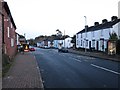
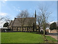
Primrose Close, Halton
Primrose Close, Halton
Image: © Mike Harris
Taken: 14 Jan 2007
0.12 miles
5
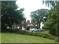
Castle Inn
Castle Inn on the site of the Medieval Castle Runcorn Cheshire
Image: © russ
Taken: 10 Jul 2005
0.20 miles
8
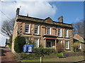
Halton Vicarage, Halton Village
Situated on the road up to Halton Castle, the vicarage was built in 1739 of local sandstone blocks, the doric porch was added at a later date. It is a grade II listed building.
Image: © Sue Adair
Taken: 1 Apr 2008
0.24 miles
9
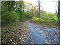
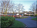
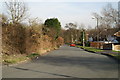
Public footpath in Town Park
Heading up the pedestrianised Nortons Lane
Image: © Maggie Cox
Taken: 14 Nov 2013
0.25 miles