IMAGES TAKEN NEAR TO
Halton Brow, RUNCORN, WA7 2EJ
Introduction
This page details the photographs taken nearby to Halton Brow, WA7 2EJ by members of the Geograph project.
The Geograph project started in 2005 with the aim of publishing, organising and preserving representative images for every square kilometre of Great Britain, Ireland and the Isle of Man.

There are currently over 7.5m images from over14,400 individuals and you can help contribute to the project by visiting https://www.geograph.org.uk
Image Map
Images are licensed for reuse under creativecommons.org/licenses/by-sa/2.0
Notes
- Clicking on the map will re-center to the selected point.
- The higher the marker number, the further away the image location is from the centre of the postcode.
Image Listing (2 Images Found)
Images are licensed for reuse under creativecommons.org/licenses/by-sa/2.0
Image
Details
Distance
1
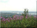
View from Castle - River Mersey
Taken from Castle hill, Runcorn. View towards Frodsham, Helsby & Widnes; also the Silver Jubilee bridge.
Image: © russ
Taken: 10 Jul 2005
0.11 miles
2
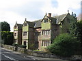
Seneschal's House, Halton village
The Seneschal's House is an 'E' shaped building dating from 1598, formerly Halton Brow Farm House and now a private residence.
Image: © Sue Adair
Taken: 1 Apr 2008
0.24 miles