IMAGES TAKEN NEAR TO
Malmesbury Park, RUNCORN, WA7 1XD
Introduction
This page details the photographs taken nearby to Malmesbury Park, WA7 1XD by members of the Geograph project.
The Geograph project started in 2005 with the aim of publishing, organising and preserving representative images for every square kilometre of Great Britain, Ireland and the Isle of Man.

There are currently over 7.5m images from over14,400 individuals and you can help contribute to the project by visiting https://www.geograph.org.uk
Image Map
Images are licensed for reuse under creativecommons.org/licenses/by-sa/2.0
Notes
- Clicking on the map will re-center to the selected point.
- The higher the marker number, the further away the image location is from the centre of the postcode.
Image Listing (5 Images Found)
Images are licensed for reuse under creativecommons.org/licenses/by-sa/2.0
Image
Details
Distance
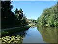
4
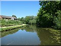
Cyclist on the Bridgewater Canal towpath, Norton
The half-hidden housing is in Adlington Road.
Image: © Christine Johnstone
Taken: 30 May 2021
0.21 miles
5
Civil parish boundary between Sandymoor and Halton
Unusually, the boundary runs down the middle of the Bridgewater canal here at Norton, on the outskirts of Runcorn.
Image: © Christine Johnstone
Taken: 30 May 2021
0.24 miles