IMAGES TAKEN NEAR TO
Devonshire Place, RUNCORN, WA7 1WF
Introduction
This page details the photographs taken nearby to Devonshire Place, WA7 1WF by members of the Geograph project.
The Geograph project started in 2005 with the aim of publishing, organising and preserving representative images for every square kilometre of Great Britain, Ireland and the Isle of Man.

There are currently over 7.5m images from over14,400 individuals and you can help contribute to the project by visiting https://www.geograph.org.uk
Image Map
Images are licensed for reuse under creativecommons.org/licenses/by-sa/2.0
Notes
- Clicking on the map will re-center to the selected point.
- The higher the marker number, the further away the image location is from the centre of the postcode.
Image Listing (293 Images Found)
Images are licensed for reuse under creativecommons.org/licenses/by-sa/2.0
Image
Details
Distance
1
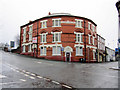
Victoria Buildings SES 1892
Victoria Buildings stand at the corner of High Street and Greenway Road. The name, high above the front door, also has the initials SES.
Image: © John S Turner
Taken: 16 Dec 2010
0.00 miles
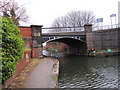
2
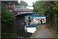
Bridgewater Canal, Runcorn
An elderly couple survey the scene close to the end of the Runcorn Arm of the Bridgewater Canal.
Image: © Stephen McKay
Taken: 17 Jul 2007
0.00 miles
3
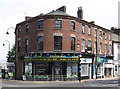
Runcorn - Devonshire Buildings
On High Street.
Image: © Dave Bevis
Taken: 9 Aug 2012
0.01 miles
4
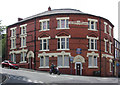
Runcorn - Victoria Buildings
On Devonshire Place. For an alternative view, please see Image
Image: © Dave Bevis
Taken: 9 Aug 2012
0.02 miles
5
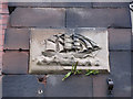
Plaque on Doctor's Bridge
This interesting stone plaque depicting a sailing ship is on the north west face of Doctor's bridge. Perhaps it represents the connection between the canal and the sailing ships on the River Mersey a short distance away?
Image: © John S Turner
Taken: 16 Dec 2010
0.02 miles
7
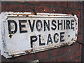
Old name plate in Devonshire Place
This old name plate is attached to the buildings on the west side of Devonshire Place.
Image: © John S Turner
Taken: 16 Dec 2010
0.02 miles
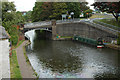
8
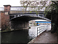
Doctor's Bridge over the Bridgewater Canal
Looking east toward Doctor's Bridge over the Bridgewater Canal. Prior to 1899 the bridge was named Runcorn Bridge on the O.S. maps. Note the stone plaque on the left-hand bridge abutment - Image
Image: © John S Turner
Taken: 16 Dec 2010
0.02 miles
9
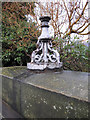
Remains of a lamp on Doctor's Bridge
The remains of an old gas lamp on the parapet of Doctor's Bridge, Greenway Road. See also Image
Image: © John S Turner
Taken: 16 Dec 2010
0.02 miles
10
Doctor's Bridge from the towpath
A view of Doctor's Bridge from the towpath alongside the Bridgewater Canal. Prior to 1899 the bridge was named Runcorn Bridge on the O.S maps.
Image: © John S Turner
Taken: 16 Dec 2010
0.02 miles