IMAGES TAKEN NEAR TO
Warrington Road, RUNCORN, WA7 1RB
Introduction
This page details the photographs taken nearby to Warrington Road, WA7 1RB by members of the Geograph project.
The Geograph project started in 2005 with the aim of publishing, organising and preserving representative images for every square kilometre of Great Britain, Ireland and the Isle of Man.

There are currently over 7.5m images from over14,400 individuals and you can help contribute to the project by visiting https://www.geograph.org.uk
Image Map
Images are licensed for reuse under creativecommons.org/licenses/by-sa/2.0
Notes
- Clicking on the map will re-center to the selected point.
- The higher the marker number, the further away the image location is from the centre of the postcode.
Image Listing (15 Images Found)
Images are licensed for reuse under creativecommons.org/licenses/by-sa/2.0
Image
Details
Distance
1
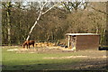
Not far from the madding crowd
Within yards of a major industrial estate on the edge of Runcorn New Town
Image: © David Long
Taken: 22 Mar 2006
0.04 miles


5
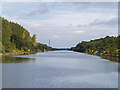
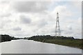
Manchester Ship Canal near Halton
The Manchester Ship Canal east of Halton, with pylons carrying the transmission grid over the canal at Round Chevaral visible in the distance.
Image: © William Starkey
Taken: 21 Sep 2013
0.16 miles
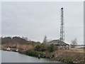
6
Overhead Power Lines Crossing the Manchester Ship Canal
Image: © David Dixon
Taken: 11 May 2016
0.17 miles
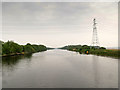
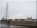
7
Power lines over the canal
Power lines associated with Fiddler's Ferry power station cross the Manchester Ship Canal.
Image: © Trevor Harris
Taken: 2 Sep 2012
0.18 miles

9
Air draft gauge for ships, at Round Chevaral
Pairs of towers sling wires across the Manchester Ship Canal to warn ships that are too high to pass under nearby obstructions [power lines, bridges etc]. Image shows the derelict building from the other side.
Image: © Christine Johnstone
Taken: 13 Apr 2013
0.19 miles
10
Power lines at Round Chevaral
Crossing the Mersey and then the Manchester Ship Canal, south from Fiddlers Ferry power station.
Image: © Christine Johnstone
Taken: 13 Apr 2013
0.21 miles