IMAGES TAKEN NEAR TO
Astmoor Road, RUNCORN, WA7 1QQ
Introduction
This page details the photographs taken nearby to Astmoor Road, WA7 1QQ by members of the Geograph project.
The Geograph project started in 2005 with the aim of publishing, organising and preserving representative images for every square kilometre of Great Britain, Ireland and the Isle of Man.

There are currently over 7.5m images from over14,400 individuals and you can help contribute to the project by visiting https://www.geograph.org.uk
Image Map
Images are licensed for reuse under creativecommons.org/licenses/by-sa/2.0
Notes
- Clicking on the map will re-center to the selected point.
- The higher the marker number, the further away the image location is from the centre of the postcode.
Image Listing (9 Images Found)
Images are licensed for reuse under creativecommons.org/licenses/by-sa/2.0
Image
Details
Distance
6
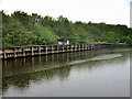
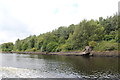
Manchester Ship Canal beacon 213
Beside a drain off Wigg Island.
Image: © Trevor Harris
Taken: 2 Sep 2012
0.21 miles
7
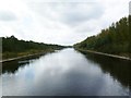
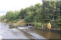
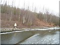
Manchester Ship Canal
Drain outlet on Wigg Island.
Image: © Alan Heardman
Taken: 13 Jul 2014
0.22 miles
8
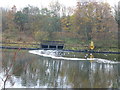
Gulls congregate at sewage farm outlet on the Manchester Ship Canal
Image: © Raymond Knapman
Taken: 28 Nov 2013
0.24 miles
9
Manchester Ship Canal beacon 212
On the north bank, at Wigg Island.
Image: © Christine Johnstone
Taken: 13 Apr 2013
0.24 miles