IMAGES TAKEN NEAR TO
Astmoor Road, RUNCORN, WA7 1PJ
Introduction
This page details the photographs taken nearby to Astmoor Road, WA7 1PJ by members of the Geograph project.
The Geograph project started in 2005 with the aim of publishing, organising and preserving representative images for every square kilometre of Great Britain, Ireland and the Isle of Man.

There are currently over 7.5m images from over14,400 individuals and you can help contribute to the project by visiting https://www.geograph.org.uk
Image Map
Images are licensed for reuse under creativecommons.org/licenses/by-sa/2.0
Notes
- Clicking on the map will re-center to the selected point.
- The higher the marker number, the further away the image location is from the centre of the postcode.
Image Listing (47 Images Found)
Images are licensed for reuse under creativecommons.org/licenses/by-sa/2.0
Image
Details
Distance
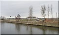
1
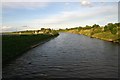
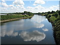
Manchester Ship Canal at Halton
Looking east from the old swing bridge leading to Wigg Island Community Park.
Image: © Bob Jones
Taken: 14 Jul 2007
0.09 miles
2
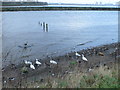
Ducks and Geese on the Mersey at Runcorn
Image: © Eirian Evans
Taken: 5 Jan 2012
0.10 miles
3
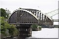
Old Quay Bridge
** Old Quay Bridge is a swing bridge across the Manchester Ship Canal from Runcorn to Wigg Island. The bridge was built circa 1894. It took its name from the Old Quay Canal, which is more commonly known as the Runcorn to Latchford Canal.
** Courtesy Wikipedia
Image: © Arthur C Harris
Taken: 28 Jun 2022
0.12 miles
4
Bird Hide at Wigg Island
One of several bird hides at Wigg Island Community Park, this one situated by the car park, with the Runcorn Widnes Bridge in the background. The Park is situated between the Manchester Ship Canal and the River Mersey.
Image: © John S Turner
Taken: 16 Nov 2006
0.12 miles
5
Wigg Island bird hide
On the north bank of the Manchester Ship Canal.
Image: © Christine Johnstone
Taken: 13 Apr 2013
0.12 miles
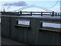
6
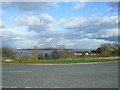
View from Mason Street to Wigg Island, with Fiddlers Ferry power station beyond
Image: © Colin Pyle
Taken: 2 Nov 2012
0.13 miles
7
Manchester Ship Canal, Wigg Island Visitor Centre
Wigg Island, also known as Wigg Island Community Park, is a Local Nature Reserve which lies between the River Mersey and the Manchester Ship Canal near Runcorn.
Image: © David Dixon
Taken: 11 May 2016
0.13 miles
8
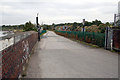
Road to Wigg Island
Wigg Island was formerly the site of Wigg's chemical factory, processing by-products of the sulphuric acid industry, but has been developed as a community park and nature reserve.
Image: © Alan Murray-Rust
Taken: 6 Oct 2008
0.13 miles
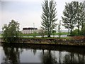
9
Manchester Ship Canal
The Manchester Ship Canal looking East from The Old Quay Swing Bridge.
Image: © Sue Adair
Taken: 4 Jul 2008
0.14 miles
10
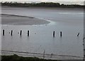
Sand bank on the Mersey
A sandbank on the River Mersey at low tide provides a suitable fishing spot for a heron (top right hand edge of the sandbank). Taken from near the new Wigg Island visitor centre (opening Spring 2007).
Image: © John S Turner
Taken: 16 Nov 2006
0.14 miles