IMAGES TAKEN NEAR TO
Brindley Road, RUNCORN, WA7 1PF
Introduction
This page details the photographs taken nearby to Brindley Road, WA7 1PF by members of the Geograph project.
The Geograph project started in 2005 with the aim of publishing, organising and preserving representative images for every square kilometre of Great Britain, Ireland and the Isle of Man.

There are currently over 7.5m images from over14,400 individuals and you can help contribute to the project by visiting https://www.geograph.org.uk
Image Map
Images are licensed for reuse under creativecommons.org/licenses/by-sa/2.0
Notes
- Clicking on the map will re-center to the selected point.
- The higher the marker number, the further away the image location is from the centre of the postcode.
Image Listing (6 Images Found)
Images are licensed for reuse under creativecommons.org/licenses/by-sa/2.0
Image
Details
Distance
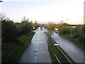
1

Brindley Road, Astmoor Industrial Estate
Image: © Alex McGregor
Taken: 18 Oct 2011
0.11 miles
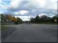
2

Industrial units, Runcorn
Taken from the footpath behind the Pharmaserve North West warehouse.
Image: © Matt Harrop
Taken: 11 Apr 2015
0.12 miles
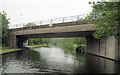
4

Astmoor Bridge 78
Bridgewater Canal - Runcorn Section
Image: © Mike Todd
Taken: 16 May 2011
0.15 miles
6
Expressway Bridge
Bridgewater Canal - Runcorn Section
Image: © Mike Todd
Taken: 16 May 2011
0.24 miles