IMAGES TAKEN NEAR TO
Egerton Road, RUNCORN, WA7 1JN
Introduction
This page details the photographs taken nearby to Egerton Road, WA7 1JN by members of the Geograph project.
The Geograph project started in 2005 with the aim of publishing, organising and preserving representative images for every square kilometre of Great Britain, Ireland and the Isle of Man.

There are currently over 7.5m images from over14,400 individuals and you can help contribute to the project by visiting https://www.geograph.org.uk
Image Map
Images are licensed for reuse under creativecommons.org/licenses/by-sa/2.0
Notes
- Clicking on the map will re-center to the selected point.
- The higher the marker number, the further away the image location is from the centre of the postcode.
Image Listing (310 Images Found)
Images are licensed for reuse under creativecommons.org/licenses/by-sa/2.0
Image
Details
Distance
1
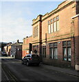
Carnegie Library, Egerton Street, Runcorn
Grade II Listed building viewed in February 2017.
THE GIFT OF ANDREW CARNEGIE 1906 https://www.geograph.org.uk/photo/6659682 is embossed over the entrance.
Carnegie libraries were built with money donated by Scottish-American businessman and philanthropist Andrew Carnegie. More than 2,500 Carnegie libraries were built worldwide.
Image: © Jaggery
Taken: 4 Feb 2017
0.01 miles
2
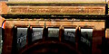
The Gift of Andrew Carnegie 1906, Egerton Street, Runcorn
Embossed above the entrance to this https://www.geograph.org.uk/photo/6659669 Grade II Listed Carnegie Library.
Image: © Jaggery
Taken: 4 Feb 2017
0.01 miles
3
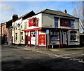
The Wellington, Runcorn
Pub on the corner of Egerton Street and Wellington Street.
Image: © Jaggery
Taken: 4 Feb 2017
0.02 miles
4
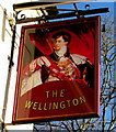
The Wellington name sign, Runcorn
On the corner here. http://www.geograph.org.uk/photo/5274018
Image: © Jaggery
Taken: 4 Feb 2017
0.02 miles
5
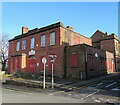
Former Waterloo Community Centre, Runcorn
The Waterloo Community Centre name remains on the derelict Waterloo Road building in February 2017. An August 2014 Google Street View shows similar dereliction.
Image: © Jaggery
Taken: 4 Feb 2017
0.02 miles
6
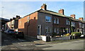
Houses near a Runcorn corner
Waterloo Road is on the right. Egerton Street is on the left.
Image: © Jaggery
Taken: 4 Feb 2017
0.03 miles
8
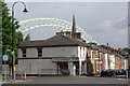
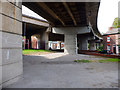
Runcorn
Showing the junction of Bridgewater Street (straight ahead) and Egerton Street (to the left) with the Runcorn - Widnes bridge in the background. The street names are appropriate; it was Francis Egerton, 3rd Duke of Bridgewater, who built the Bridgewater Canal, which was the basis for the town's original prosperity. In more recent times, however, Runcorn has become associated with chemical and hi-tech industries.
Image: © Stephen McKay
Taken: 17 Jul 2007
0.05 miles
10
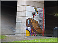
Skater Graffiti under Queensway, Runcorn
Image: © Gary Rogers
Taken: 21 Aug 2018
0.05 miles