IMAGES TAKEN NEAR TO
High Street, RUNCORN, WA7 1JH
Introduction
This page details the photographs taken nearby to High Street, WA7 1JH by members of the Geograph project.
The Geograph project started in 2005 with the aim of publishing, organising and preserving representative images for every square kilometre of Great Britain, Ireland and the Isle of Man.

There are currently over 7.5m images from over14,400 individuals and you can help contribute to the project by visiting https://www.geograph.org.uk
Image Map
Images are licensed for reuse under creativecommons.org/licenses/by-sa/2.0
Notes
- Clicking on the map will re-center to the selected point.
- The higher the marker number, the further away the image location is from the centre of the postcode.
Image Listing (305 Images Found)
Images are licensed for reuse under creativecommons.org/licenses/by-sa/2.0
Image
Details
Distance
1
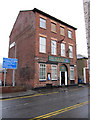
R.A.O.B. Social Club, 78 High Street
Looking across High Street towards the R.A.O.B. Social Club at #78.
Image: © John S Turner
Taken: 16 Dec 2010
0.01 miles
2
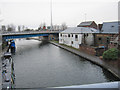
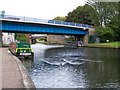
High Street, Runcorn
A boater's view, looking under Queensway [part of the approach to the Silver Jubilee Bridge across the River Mersey].
Image: © Christine Johnstone
Taken: 30 May 2021
0.01 miles
3
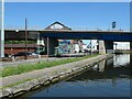
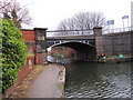
Bridgewater Canal basin by Doctor's Bridge
Looking down on the canal basin alongside Doctor's Bridge. Beyond the modern flyover is Waterloo Bridge.
Image: © John S Turner
Taken: 16 Dec 2010
0.02 miles
4
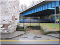
Old loading bay next to the Bridgewater Canal
An interesting remnant from a byegone age this looks to me like a loading bay for a horse-drawn cart. Just behind is the Bridgewater Canal basin where old maps indicate cranes on the side of the canal. There was also a warehouse nearby.
Image: © John S Turner
Taken: 16 Dec 2010
0.02 miles
5
Bridge carrying A533 slip road over the Bridgewater Canal
Looking east: the original bridge beyond is a rather more elegant structure than its modern neighbour!
Image: © David Martin
Taken: 6 Aug 2010
0.02 miles
6
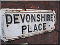
Old name plate in Devonshire Place
This old name plate is attached to the buildings on the west side of Devonshire Place.
Image: © John S Turner
Taken: 16 Dec 2010
0.03 miles
7
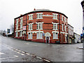
Victoria Buildings SES 1892
Victoria Buildings stand at the corner of High Street and Greenway Road. The name, high above the front door, also has the initials SES.
Image: © John S Turner
Taken: 16 Dec 2010
0.03 miles
8
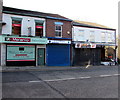
Melenio Italiano Ristorante, Runcorn
Italian cuisine restaurant at 60 Devonshire Place.
Image: © Jaggery
Taken: 4 Feb 2017
0.03 miles
9
Doctor's Bridge over the Bridgewater Canal
Looking east toward Doctor's Bridge over the Bridgewater Canal. Prior to 1899 the bridge was named Runcorn Bridge on the O.S. maps. Note the stone plaque on the left-hand bridge abutment - Image
Image: © John S Turner
Taken: 16 Dec 2010
0.03 miles
10
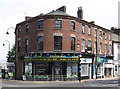
Runcorn - Devonshire Buildings
On High Street.
Image: © Dave Bevis
Taken: 9 Aug 2012
0.03 miles