IMAGES TAKEN NEAR TO
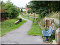
Red Pier Crescent, RUNCORN, WA7 1JD
Introduction
This page details the photographs taken nearby to Red Pier Crescent, WA7 1JD by members of the Geograph project.
The Geograph project started in 2005 with the aim of publishing, organising and preserving representative images for every square kilometre of Great Britain, Ireland and the Isle of Man.

There are currently over 7.5m images from over14,400 individuals and you can help contribute to the project by visiting https://www.geograph.org.uk
Image Map
Images are licensed for reuse under creativecommons.org/licenses/by-sa/2.0
Notes
- Clicking on the map will re-center to the selected point.
- The higher the marker number, the further away the image location is from the centre of the postcode.
Image Listing (94 Images Found)
Images are licensed for reuse under creativecommons.org/licenses/by-sa/2.0
Image
Details
Distance
1
Path between Algernon Street and Old Coach Road, Runcorn
Image: © Gary Rogers
Taken: 21 Aug 2018
0.05 miles
2
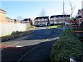
Redtail Close, Runcorn
Cul-de-sac on the southeast side of Old Coach Road.
Image: © Jaggery
Taken: 4 Feb 2017
0.07 miles
3
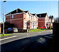
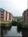
Bridgewater House, Runcorn
Bridgewater House was built by the Duke of Bridgewater around 1760 as a temporary residence during the construction of his canal. The docks seem a strange setting for such an elegant Georgian house and after the filling in of the ladder of locks and gradual deterioration of the dock area the house became somewhat isolated but in the last few years new apartments and a college have been built and the listed building is now the jewel in the crown of Runcorn's riverside regeneration.
Image: © Sue Adair
Taken: 6 Jan 2008
0.10 miles
4
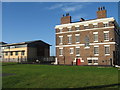
Old Coach Road flats, Runcorn
Four-storey block of flats on the south bank of the River Mersey.
Image: © Jaggery
Taken: 4 Feb 2017
0.11 miles
5
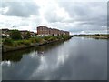
Former Junction of Bridgewater Canal with Manchester Ship Canal
The line of the former series (staircase ?) of locks has been preserved when the new building took place
Image: © Michael Steele
Taken: 17 Sep 2008
0.12 miles
6
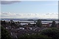
Across the rooftops, Runcorn
Immediately over the Mersey Estuary is Hale. In the background, the highest of the visible Welsh hills, centre right, is Moel Famau. Stanlow is over the Mersey Basin, to the centre left.
Image: © El Pollock
Taken: 8 Jun 2014
0.12 miles
7
Gleanor Close, Runcorn
Cul-de-sac on the southeast side of Old Coach Road.
Image: © Jaggery
Taken: 4 Feb 2017
0.12 miles
8
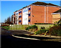
Runcorn, canalside housing
Modern apartments on Old Coach Road, overlooking Manchester Ship Canal.
Image: © Mike Faherty
Taken: 18 Sep 2011
0.13 miles
9
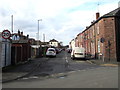
Bentinck Street, Runcorn
From Brindley Street along Bentinck Street towards Trentham Street. The 30mph speed limit drops to 20mph.
Image: © Jaggery
Taken: 4 Feb 2017
0.13 miles
10
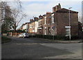
Leinster Gardens, Runcorn
Viewed from Percival Lane. The 30mph speed limit drops to 20mph.
Image: © Jaggery
Taken: 4 Feb 2017
0.13 miles