IMAGES TAKEN NEAR TO
High Street, RUNCORN, WA7 1AQ
Introduction
This page details the photographs taken nearby to High Street, WA7 1AQ by members of the Geograph project.
The Geograph project started in 2005 with the aim of publishing, organising and preserving representative images for every square kilometre of Great Britain, Ireland and the Isle of Man.

There are currently over 7.5m images from over14,400 individuals and you can help contribute to the project by visiting https://www.geograph.org.uk
Image Map
Images are licensed for reuse under creativecommons.org/licenses/by-sa/2.0
Notes
- Clicking on the map will re-center to the selected point.
- The higher the marker number, the further away the image location is from the centre of the postcode.
Image Listing (228 Images Found)
Images are licensed for reuse under creativecommons.org/licenses/by-sa/2.0
Image
Details
Distance
1
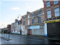
Demolition site on High Street
This decaying old building in High Street is scheduled for demolition in 2011.
Image: © John S Turner
Taken: 16 Dec 2010
0.00 miles
4
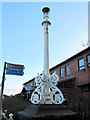
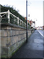
Lamppost outside St Paul's Centre
This old lamppost is part of the Grade II listing of the walls and terrace outside the modern St Paul's Centre in High Street. The centre is on the site of St Paul's Wesleyan Chapel which was opened in 1866 and had seating for 1,600 people. http://www.britishlistedbuildings.co.uk/en-351188-terrace-walls-piers-and-railings-to-st-p See also Image
Image: © John S Turner
Taken: 16 Dec 2010
0.01 miles
5
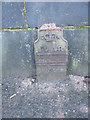
Old GPO cable marker in High Street
This old cast iron marker is on the south side of High Street and carries the insignia for King George, suggesting a date between 1910-1936. Originally there would also have been a plaque below the 'ft ins' (feet and inches), indicating the actual distance to a buried GPO cable. The arrow signifies that the General Post Office was a government department at that time.
Image: © John S Turner
Taken: 16 Dec 2010
0.01 miles
6
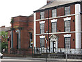
Runcorn - Camden Buildings
On High Street. Date-stone says 1870. For an alternative view, please see Image
Image: © Dave Bevis
Taken: 9 Aug 2012
0.02 miles

8
The Terrace Walls and Railings to St Paul's Health Centre, Runcorn
These Grade II listed walls and railings are in front of the modern St Paul's Health Centre on High Street. http://www.britishlistedbuildings.co.uk/en-351188-terrace-walls-piers-and-railings-to-st-p Originally the walls and the terrace above were in front of St Paul's Wesleyan Chapel, which had seating for 1,600 people. The foundation stone of the chapel was laid in 1864, and it was opened in 1866. Examination of the O.S. maps online suggests that the chapel was demolished between 1964 and 1968.
Image: © John S Turner
Taken: 16 Dec 2010
0.02 miles
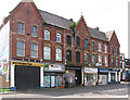
9
Runcorn - NatWest Bank and offices on High Street
Image: © Dave Bevis
Taken: 9 Aug 2012
0.02 miles
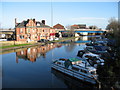
10
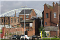
Runcorn
Runcorn is a 1960s new town developed to relieve population pressures elsewhere in the north-west; the old part of the town, however, is collected around the Bridgewater Canal close to the River Mersey. This picture shows the back of commercial properties on High Street, seen from the canal bank. The Runcorn - Widnes road bridge, opened in 1961, looms over the scene.
Image: © Stephen McKay
Taken: 17 Jul 2007
0.02 miles