IMAGES TAKEN NEAR TO
High Street, RUNCORN, WA7 1AH
Introduction
This page details the photographs taken nearby to High Street, WA7 1AH by members of the Geograph project.
The Geograph project started in 2005 with the aim of publishing, organising and preserving representative images for every square kilometre of Great Britain, Ireland and the Isle of Man.

There are currently over 7.5m images from over14,400 individuals and you can help contribute to the project by visiting https://www.geograph.org.uk
Image Map
Images are licensed for reuse under creativecommons.org/licenses/by-sa/2.0
Notes
- Clicking on the map will re-center to the selected point.
- The higher the marker number, the further away the image location is from the centre of the postcode.
Image Listing (240 Images Found)
Images are licensed for reuse under creativecommons.org/licenses/by-sa/2.0
Image
Details
Distance
1
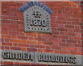
Camden Buildings 1870, High Street, Runcorn
Part of the central gable here. http://www.geograph.org.uk/photo/5273281
Image: © Jaggery
Taken: 4 Feb 2017
0.00 miles
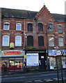
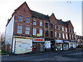
2
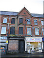
Camden Buildings, High Street, Runcorn
Looking across High Street towards the centre of Camden Buildings. They were built in 1870, and the C.W.& W. Stringer shop has seen better days.
Image: © John S Turner
Taken: 16 Dec 2010
0.00 miles
3
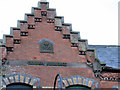
The central gable of Camden Buildings 1870
Looking across High Street towards the central gable of Camden Buildings dated 1870. See also Image
Image: © John S Turner
Taken: 16 Dec 2010
0.00 miles
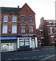
4
Mama Mia, High Street, Runcorn
The takeaway (kebabs, fried chicken, pizza, burgers etc) is at 61 High Street.
Image: © Jaggery
Taken: 4 Feb 2017
0.00 miles
5
Buildings on the south side of High Street, Runcorn
The green metal arch is part of the Silver Jubilee Bridge, across the Mersey.
Image: © Christine Johnstone
Taken: 30 May 2021
0.01 miles
6
Camden Buildings, High Street, Runcorn
The inscription on the central gable shows the year 1870. http://www.geograph.org.uk/photo/5273285
Image: © Jaggery
Taken: 4 Feb 2017
0.01 miles
7
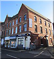
Holistic House, Runcorn
Health food retailers at 69 High Street.
Image: © Jaggery
Taken: 4 Feb 2017
0.01 miles
8
Chinese Open Kitchen and Holistic House, Runcorn
Two High Street businesses.
Image: © Jaggery
Taken: 4 Feb 2017
0.01 miles
9
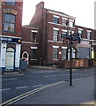
High Street signpost, Runcorn
Opposite Holistic House. http://www.geograph.org.uk/photo/5273357
Image: © Jaggery
Taken: 4 Feb 2017
0.01 miles
10
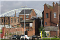
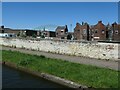
Runcorn
Runcorn is a 1960s new town developed to relieve population pressures elsewhere in the north-west; the old part of the town, however, is collected around the Bridgewater Canal close to the River Mersey. This picture shows the back of commercial properties on High Street, seen from the canal bank. The Runcorn - Widnes road bridge, opened in 1961, looms over the scene.
Image: © Stephen McKay
Taken: 17 Jul 2007
0.01 miles