IMAGES TAKEN NEAR TO
The Paddock, FRODSHAM, WA6 9PY
Introduction
This page details the photographs taken nearby to The Paddock, WA6 9PY by members of the Geograph project.
The Geograph project started in 2005 with the aim of publishing, organising and preserving representative images for every square kilometre of Great Britain, Ireland and the Isle of Man.

There are currently over 7.5m images from over14,400 individuals and you can help contribute to the project by visiting https://www.geograph.org.uk
Image Map
Images are licensed for reuse under creativecommons.org/licenses/by-sa/2.0
Notes
- Clicking on the map will re-center to the selected point.
- The higher the marker number, the further away the image location is from the centre of the postcode.
Image Listing (22 Images Found)
Images are licensed for reuse under creativecommons.org/licenses/by-sa/2.0
Image
Details
Distance
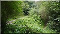
1
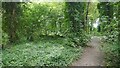
Helsby Quarry Nature Reserve
A path parallel to Alvanley Road.
Image: © Richard Webb
Taken: 15 Aug 2019
0.08 miles
2
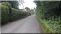
Alvanley Road, Helsby
Passing the Quarry nature reserve. An area of well spread large houses.
Image: © Richard Webb
Taken: 15 Aug 2019
0.08 miles
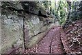
3
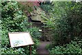
Helsby Quarry, The Wall Exposier
The information board explains that this rock wall is part of the Helsby Sandstone Formation and was originally formed from deposits laid down approximately 250 million years ago.
Image: © Jeff Buck
Taken: 4 Oct 2012
0.09 miles
4
Helsby (Mountskill) Quarry
The nearby information board explains that this rock wall is part of the Helsby Sandstone Formation and was originally formed from deposits laid down approximately 250 million years ago.
Image: © Jeff Buck
Taken: 4 Oct 2012
0.09 miles
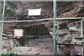
5
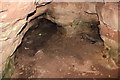
Helsby Quarry
The nearby information board explains that the rock wall which these holes enter is part of the Helsby Sandstone Formation and was originally formed from deposits laid down approximately 250 million years ago.
Image: © Jeff Buck
Taken: 4 Oct 2012
0.10 miles
6
Helsby Quarry Nature Reserve
A sandstone quarry halfway up Helsby Hill. View from near the car park.
Image: © Richard Webb
Taken: 15 Aug 2019
0.10 miles
7
Sandstone Outcrop at Helsby Quarry (Mountskill Quarry)
Wikipedia http://en.wikipedia.org/wiki/Helsby#Mountskill_Quarry
Image: © Jeff Buck
Taken: 4 Oct 2012
0.10 miles
8
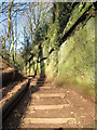
Footpath in Helsby Quarry
Helsby Quarry Woodland Park was once a working quarry called Mountskill Quarry. Sandstone was extracted from the early 1800s until the 1920s, the site being used as a tip until it was reclaimed and transformed in the late 1980s and opened as a Local Nature Reserve in 1990. Nearby is a rock tunnel through which a tramway once ran transporting sandstone to Ince pier on the River Mersey.
Image: © Sue Adair
Taken: 16 Feb 2013
0.10 miles
9
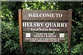
Helsby Quarry Sign
The sign in the car park at Helsby Quarry nature reserve.
Image: © Jeff Buck
Taken: 4 Oct 2012
0.11 miles
10
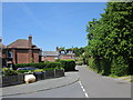
Alvanley Road, Helsby
Alvanley Road at the junction with Nemos Close heading looking north towards the village.
Image: © Jeff Buck
Taken: 10 Jun 2015
0.11 miles