IMAGES TAKEN NEAR TO
Vicarage Lane, FRODSHAM, WA6 9AB
Introduction
This page details the photographs taken nearby to Vicarage Lane, WA6 9AB by members of the Geograph project.
The Geograph project started in 2005 with the aim of publishing, organising and preserving representative images for every square kilometre of Great Britain, Ireland and the Isle of Man.

There are currently over 7.5m images from over14,400 individuals and you can help contribute to the project by visiting https://www.geograph.org.uk
Image Map
Images are licensed for reuse under creativecommons.org/licenses/by-sa/2.0
Notes
- Clicking on the map will re-center to the selected point.
- The higher the marker number, the further away the image location is from the centre of the postcode.
Image Listing (53 Images Found)
Images are licensed for reuse under creativecommons.org/licenses/by-sa/2.0
Image
Details
Distance
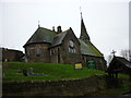
4
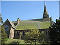
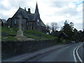
St Paul's, Helsby
St Paul's church, Helsby, consecrated in 1870.
Image: © Sue Adair
Taken: 3 May 2007
0.05 miles

8
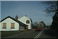
Mill Rise, Helsby
A short, apparently recently built cul de sac off Chester Road.
Image: © Richard Vince
Taken: 1 Jun 2019
0.06 miles
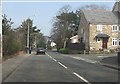
9
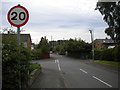
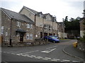
Bank House Lane, Helsby
A 20mph residential road off Chester Road, leading down to the railway line. The junction with Hallastone Road is visible on the left.
Image: © Richard Vince
Taken: 1 Jun 2019
0.06 miles