IMAGES TAKEN NEAR TO
Foxglove Court, FRODSHAM, WA6 7QG
Introduction
This page details the photographs taken nearby to Foxglove Court, WA6 7QG by members of the Geograph project.
The Geograph project started in 2005 with the aim of publishing, organising and preserving representative images for every square kilometre of Great Britain, Ireland and the Isle of Man.

There are currently over 7.5m images from over14,400 individuals and you can help contribute to the project by visiting https://www.geograph.org.uk
Image Map
Images are licensed for reuse under creativecommons.org/licenses/by-sa/2.0
Notes
- Clicking on the map will re-center to the selected point.
- The higher the marker number, the further away the image location is from the centre of the postcode.
Image Listing (19 Images Found)
Images are licensed for reuse under creativecommons.org/licenses/by-sa/2.0
Image
Details
Distance
1
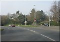
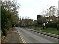
Frodsham - Red Lane's junction with Fluin Lane
Image: © Peter Whatley
Taken: 23 Mar 2012
0.14 miles

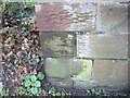
5
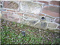
Cut Mark: Church Street, Frodsham
Upside down OS Cut Mark on a roadside wall on Church Street, Frodsham. Number B11332 on the Benchmark Database, see http://www.bench-marks.org.uk/bm37711
Image: © VBForever
Taken: 22 Apr 2011
0.21 miles

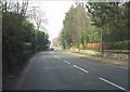
7
Cut Mark: Vicarage Lane, Overton
OS Cut Mark on roadside wall on Vicarage Lane, Overton, Frodsham. Number BM7752 on the Benchmark Database, see http://www.bench-marks.org.uk/bm33383
Image: © VBForever
Taken: 11 Mar 2011
0.22 miles
9
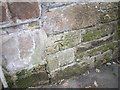
Cut Mark: St Lawrence's Church Perimeter Wall, Frodsham
OS Cut Mark on the end block of the sandstone perimeter wall of St Lawrence's Church, Frodsham. Number B10993 on the Benchmark Database, see http://www.bench-marks.org.uk/bm37339
Image: © VBForever
Taken: 18 Mar 2011
0.23 miles
10
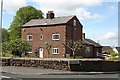
Church House Farm, Overton
Grade II listed, probably late 17th-century farmhouse in the old part of Overton, near the parish church.
Image: © Dave Dunford
Taken: 12 May 2012
0.23 miles