IMAGES TAKEN NEAR TO
Ship Street, FRODSHAM, WA6 7PD
Introduction
This page details the photographs taken nearby to Ship Street, WA6 7PD by members of the Geograph project.
The Geograph project started in 2005 with the aim of publishing, organising and preserving representative images for every square kilometre of Great Britain, Ireland and the Isle of Man.

There are currently over 7.5m images from over14,400 individuals and you can help contribute to the project by visiting https://www.geograph.org.uk
Image Map
Images are licensed for reuse under creativecommons.org/licenses/by-sa/2.0
Notes
- Clicking on the map will re-center to the selected point.
- The higher the marker number, the further away the image location is from the centre of the postcode.
Image Listing (51 Images Found)
Images are licensed for reuse under creativecommons.org/licenses/by-sa/2.0
Image
Details
Distance
1
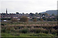
Frodsham
The village seen from the marshes. The spire belongs to Trinity Methodist Church
Image: © Alan Murray-Rust
Taken: 6 Oct 2008
0.07 miles
2
Frodsham from Weaver Lane
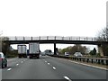
View south from the bridge over the M56 motorway.
Image: © Richard Dorrell
Taken: 24 Dec 2008
0.09 miles
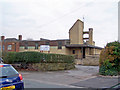
4
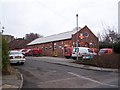
Royal Mail sorting office
Located in Ship Street, on the corner of St Luke's Way, and occupying the former St Luke's chapel.
The chapel was dedicated in 1949, and sold to the Royal Mail in 1985.
Image: © Richard Dorrell
Taken: 24 Dec 2008
0.11 miles
5
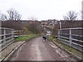
Weaver Lane, Frodsham
Weaver Lane is a farm track.
This view is from the bridge over the M56 motorway looking towards housing in Ship Street.
Image: © Richard Dorrell
Taken: 24 Dec 2008
0.11 miles
6
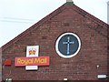
Royal Mail chapel?
The Royal Mail now operate the former St Luke's Chapel as a sorting office.
See also Image .
Image: © Richard Dorrell
Taken: 24 Dec 2008
0.11 miles
7
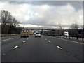
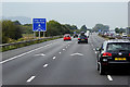
M56 Motorway approaching Weaver Lane bridge
Image: © Peter Whatley
Taken: 18 Jan 2011
0.14 miles
8
St Luke's Church, Frodsham
Opened on 8th December 1981, this Roman Catholic church has a Social Centre beneath.
Image: © Richard Dorrell
Taken: 24 Dec 2008
0.14 miles
9
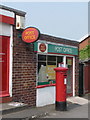
Frodsham: St. Hilda?s Drive Post Office and postbox № WA6 7
This sub post office serves northeastern Frodsham and, as well as having the door here, is accessible internally from the neighbouring convenience store.
The George V-reign postbox is emptied finally at 5:30pm on weekdays and at 10:30 on Saturday mornings.
Image: © Chris Downer
Taken: 21 Apr 2011
0.15 miles