IMAGES TAKEN NEAR TO
London Road, FRODSHAM, WA6 7DS
Introduction
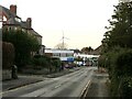
This page details the photographs taken nearby to London Road, WA6 7DS by members of the Geograph project.
The Geograph project started in 2005 with the aim of publishing, organising and preserving representative images for every square kilometre of Great Britain, Ireland and the Isle of Man.

There are currently over 7.5m images from over14,400 individuals and you can help contribute to the project by visiting https://www.geograph.org.uk
Image Map
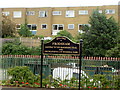
Images are licensed for reuse under creativecommons.org/licenses/by-sa/2.0
Notes
- Clicking on the map will re-center to the selected point.
- The higher the marker number, the further away the image location is from the centre of the postcode.
Image Listing (137 Images Found)
Images are licensed for reuse under creativecommons.org/licenses/by-sa/2.0
Image
Details
Distance
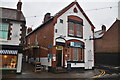
6

Cut Mark: #82 Church Street, Frodsham
OS Cut Mark on the sandstone roadside wall outside #82 Church Street, Frodsham. Number B10992 on the Benchmark Database, see http://www.bench-marks.org.uk/bm37338
Image: © VBForever
Taken: 18 Mar 2011
0.06 miles
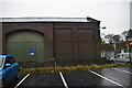
8
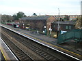
Former railway buildings by Frodsham Station
The building served sidings and was built between the mid 1870s and the mid 1890s. It is now surrounded by a car park.
Image: © Christine Johnstone
Taken: 19 Nov 2019
0.06 miles
10
Welcome to Frodsham
Located on Platform 1 at Frodsham railway station.
Image: © David Quinn
Taken: 27 Jul 2007
0.07 miles