IMAGES TAKEN NEAR TO
Chapelfields, FRODSHAM, WA6 7BB
Introduction
This page details the photographs taken nearby to Chapelfields, WA6 7BB by members of the Geograph project.
The Geograph project started in 2005 with the aim of publishing, organising and preserving representative images for every square kilometre of Great Britain, Ireland and the Isle of Man.

There are currently over 7.5m images from over14,400 individuals and you can help contribute to the project by visiting https://www.geograph.org.uk
Image Map
Images are licensed for reuse under creativecommons.org/licenses/by-sa/2.0
Notes
- Clicking on the map will re-center to the selected point.
- The higher the marker number, the further away the image location is from the centre of the postcode.
Image Listing (106 Images Found)
Images are licensed for reuse under creativecommons.org/licenses/by-sa/2.0
Image
Details
Distance
1
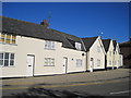
Cottages, Main Street corner with Marsh Lane
Two sets of old cottages, both bearing blue plaques, at the junction of Marsh Lane and Main Street. The first three, of which two have gables, on the right of the picture are Brookstone Cottages and were originally oak framed 17th century dwellings built at different times and restored in 1980. To the left are another three cottages restored in 1985.
Image: © Sue Adair
Taken: 25 Oct 2010
0.08 miles
2
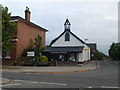
Iron Church, Frodsham
Originally built as a chapel of ease c1874 , St. Dunstan's became the temporary parish church during the restoration of St Laurence's in nearby Overton from 1880 - 83. The chapel proved unexpectedly popular, particularly with the elderly, saving many the tiring climb up to Overton. It has remained in use as a church and is today an Evangelical Chapel. In 1995 it was relocated 3 metres to the left to allow the construction of Chapelfields Road. The bell, a prominent feature above the Main Street entrance, is said to be a replica of a bell from I.K. Brunel's ship, the "Great Eastern", broken up on Tranmere beach.
Image: © Eirian Evans
Taken: 7 Aug 2010
0.08 miles
3
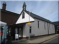
Frodsham Community Church
'Tin tabernacles' like this were once commonplace but few now survive.
Image: © Jonathan Thacker
Taken: 22 Sep 2011
0.08 miles
4
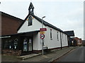
Tin tabernacle, Main Street, Frodsham
Built in 1874 and moved 3 metres in 1995. Now used by the Main Street Community Church.
Image: © Christine Johnstone
Taken: 19 Nov 2019
0.08 miles
5
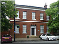
59 Main Street, Frodsham
Good five-bay house built around 1830. The Frodsham Society has affixed a plaque which states that it may have been built for Robert Wainwright Ashley, a prominent local lawyer. Grade II listed.
Image: © Stephen Richards
Taken: 17 Jun 2016
0.08 miles
6
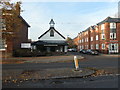
Old church, new street, Frodsham
The tin tabernacle was moved 3 metres in 1995 to make space for the Chapelfields development.
Image: © Christine Johnstone
Taken: 19 Nov 2019
0.08 miles
7
Ashley Gardens, Frodsham
A terrace of seven houses on Marsh Lane.
Image: © Christine Johnstone
Taken: 19 Nov 2019
0.08 miles
10
Barracks entrance, Frodsham
Built in 1901. It was dedicated to the 2nd Volunteer Battalion, the Cheshire regiment. The Drill hall to the rear has served as a civic centre seating 800.
Image: © Eirian Evans
Taken: 7 Aug 2010
0.10 miles