IMAGES TAKEN NEAR TO
Chester Road, FRODSHAM, WA6 6XR
Introduction
This page details the photographs taken nearby to Chester Road, WA6 6XR by members of the Geograph project.
The Geograph project started in 2005 with the aim of publishing, organising and preserving representative images for every square kilometre of Great Britain, Ireland and the Isle of Man.

There are currently over 7.5m images from over14,400 individuals and you can help contribute to the project by visiting https://www.geograph.org.uk
Image Map
Images are licensed for reuse under creativecommons.org/licenses/by-sa/2.0
Notes
- Clicking on the map will re-center to the selected point.
- The higher the marker number, the further away the image location is from the centre of the postcode.
Image Listing (6 Images Found)
Images are licensed for reuse under creativecommons.org/licenses/by-sa/2.0
Image
Details
Distance

2
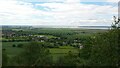
View from Woodhouse Hill
Frodsham Windfarm in distance.
Image: © Anthony Parks
Taken: Unknown
0.13 miles
3
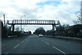
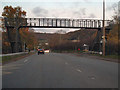
Chester Road footbridge at Helsby High School
Image: © Peter Whatley
Taken: 23 Mar 2012
0.19 miles

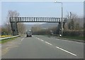
5
Chester Road Footbridge, Woodhouses
Footbridge over the A56 (Chester Road), outside Helsby High School.
Image: © David Dixon
Taken: 9 Nov 2010
0.23 miles