IMAGES TAKEN NEAR TO
Tarvin Road, FRODSHAM, WA6 6UZ
Introduction
This page details the photographs taken nearby to Tarvin Road, WA6 6UZ by members of the Geograph project.
The Geograph project started in 2005 with the aim of publishing, organising and preserving representative images for every square kilometre of Great Britain, Ireland and the Isle of Man.

There are currently over 7.5m images from over14,400 individuals and you can help contribute to the project by visiting https://www.geograph.org.uk
Image Map
Images are licensed for reuse under creativecommons.org/licenses/by-sa/2.0
Notes
- Clicking on the map will re-center to the selected point.
- The higher the marker number, the further away the image location is from the centre of the postcode.
Image Listing (14 Images Found)
Images are licensed for reuse under creativecommons.org/licenses/by-sa/2.0
Image
Details
Distance
1
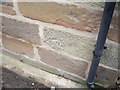
Cut Mark: Hawthorne Farm, Tarvin Road, Helsby
OS Cut Mark on sandstone wall of Hawthorne Farm, Tarvin Road, Helsby. Number B10949 on the Benchmark Database, see http://www.bench-marks.org.uk/bm37290
Image: © VBForever
Taken: 11 Mar 2011
0.01 miles
2
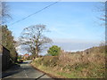
TarvIn Road near Foxhill
TarvIn Road near Foxhill
Image: © Sue Adair
Taken: 16 Feb 2013
0.04 miles
4
The North Cheshire Way near Woodhouse Hill
The North Cheshire Way heading west away from Woodhouse Hill towards Helsby and Helsby Hill.
Image: © Jeff Buck
Taken: 15 Jul 2015
0.15 miles
5
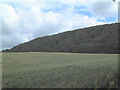
Traditional woodland near Woodhouses
Taken from the footpath at 507756 looking north east across the wheat field to the steep slopes of the wood.
Image: © Gary Rogers
Taken: 6 Jul 2005
0.16 miles
6
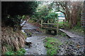
Ford on Chestnut Lane
This ford is found at the end of Chestnut Lane at Woodhouses.
Image: © John Walton
Taken: 26 Jan 2014
0.17 miles
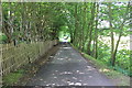
8
The North Cheshire Way below Woodhouse Hill
The North Cheshire Way, here seen heading south-west below Woodhouse Hill is one of Cheshire's newest and longest paths. It runs for 70 miles from Wirral to the Peak District.
Image: © Jeff Buck
Taken: 15 Jul 2015
0.18 miles
9
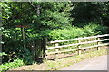
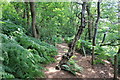
Entrance to Woodhouse Hill
The North Cheshire Way continues from here through the woods below Woodhouse Hill. Another path heads to the right up towards Woodhouses hill fort and the Sandstone Trail.
Image: © Jeff Buck
Taken: 15 Jul 2015
0.19 miles
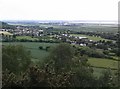
10
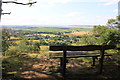
Viewpoint on Woodhouse Hill
A seat on Woodhouse Hill with a view towards Liverpool, the River Mersey and the Wirral Peninsula.
Image: © Jeff Buck
Taken: 15 Jul 2015
0.21 miles