IMAGES TAKEN NEAR TO
Mattys Lane, FRODSHAM, WA6 6UR
Introduction
This page details the photographs taken nearby to Mattys Lane, WA6 6UR by members of the Geograph project.
The Geograph project started in 2005 with the aim of publishing, organising and preserving representative images for every square kilometre of Great Britain, Ireland and the Isle of Man.

There are currently over 7.5m images from over14,400 individuals and you can help contribute to the project by visiting https://www.geograph.org.uk
Image Map
Images are licensed for reuse under creativecommons.org/licenses/by-sa/2.0
Notes
- Clicking on the map will re-center to the selected point.
- The higher the marker number, the further away the image location is from the centre of the postcode.
Image Listing (34 Images Found)
Images are licensed for reuse under creativecommons.org/licenses/by-sa/2.0
Image
Details
Distance
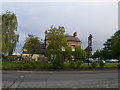
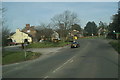
1
Mattys Lane, Netherton near Frodsham
Looking north-westwar
Image: © Peter Wood
Taken: 17 Nov 2018
0.02 miles
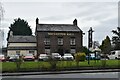
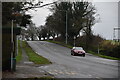
2

Enclosed footpath approaching Chester Road (A56) at Netherton
Looking north-westward.
Image: © Peter Wood
Taken: 17 Nov 2018
0.09 miles
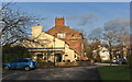
3
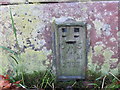
Ordnance Survey Flush Bracket 2773
This bracket can be found on a roadside (A56) wall at Netherton. The benchmark height is recorded as being 28.239 metres above sea level.
For more detail see : https://www.bench-marks.org.uk/bm2017
Image: © Peter Wood
Taken: 17 Nov 2018
0.09 miles