IMAGES TAKEN NEAR TO
Lower Rake Lane, FRODSHAM, WA6 0HU
Introduction
This page details the photographs taken nearby to Lower Rake Lane, WA6 0HU by members of the Geograph project.
The Geograph project started in 2005 with the aim of publishing, organising and preserving representative images for every square kilometre of Great Britain, Ireland and the Isle of Man.

There are currently over 7.5m images from over14,400 individuals and you can help contribute to the project by visiting https://www.geograph.org.uk
Image Map
Images are licensed for reuse under creativecommons.org/licenses/by-sa/2.0
Notes
- Clicking on the map will re-center to the selected point.
- The higher the marker number, the further away the image location is from the centre of the postcode.
Image Listing (3 Images Found)
Images are licensed for reuse under creativecommons.org/licenses/by-sa/2.0
Image
Details
Distance
1
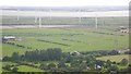
Helsby Marsh
View from Helsby Hill over Hill View Farm towards Frodsham Wind Farm and the Mersey.
Image: © Richard Webb
Taken: 15 Aug 2019
0.07 miles
2
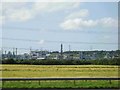
Industrial Landscape
Looking North West from M56 towards Dungeon Banks and Ince Banks
Image: © Mark Arrowsmith
Taken: Unknown
0.08 miles
3
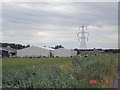
Spring Farm, Helsby
Helsby. Along footpath 23 (Rake Lane). Spring Farm and the M56. This dairy farm sits besiddes the M56 on Helsby Marsh.
Image: © Mike Harris
Taken: 8 Jul 2006
0.17 miles