IMAGES TAKEN NEAR TO
Lower Robin Hood Lane, FRODSHAM, WA6 0BW
Introduction
This page details the photographs taken nearby to Lower Robin Hood Lane, WA6 0BW by members of the Geograph project.
The Geograph project started in 2005 with the aim of publishing, organising and preserving representative images for every square kilometre of Great Britain, Ireland and the Isle of Man.

There are currently over 7.5m images from over14,400 individuals and you can help contribute to the project by visiting https://www.geograph.org.uk
Image Map
Images are licensed for reuse under creativecommons.org/licenses/by-sa/2.0
Notes
- Clicking on the map will re-center to the selected point.
- The higher the marker number, the further away the image location is from the centre of the postcode.
Image Listing (27 Images Found)
Images are licensed for reuse under creativecommons.org/licenses/by-sa/2.0
Image
Details
Distance
1
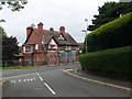
Robin Hood, Helsby
Another closed and dejected pub on the A56 Chester Road in Helsby.
Image: © Eirian Evans
Taken: 7 Aug 2010
0.03 miles
2
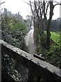
Old Chester Road
Looking down on Old Chester Road from a high bridge that carries a rough track and footpath.
Image: © John S Turner
Taken: 3 Apr 2009
0.11 miles
3
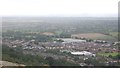
Helsby
View from Helsby Hill in light rain.
Image: © Richard Webb
Taken: 15 Aug 2019
0.11 miles
4
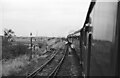
Wirral and Mersey Special at Helsby ? 1966
The tour included the line between Mouldsworth Junction and Helsby which had seen no regular passenger service since 1875, although it remained an important freight link for petrochemicals from Stanlow to the Midlands and South. This traffic had largely ceased by 1990 and the line closed in 1991. Ahead of the locomotive is the bridge crossing the main line from Chester to Manchester.
Image: © Alan Murray-Rust
Taken: 22 Oct 1966
0.14 miles
5
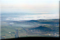
Helsby from the air
Taken from the flight deck of an Airbus inbound to Liverpool. Beyond Frodsham, extensive fog banks have yet to clear
Image: © David J Smith
Taken: 15 Oct 2007
0.16 miles
6
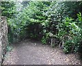
Path, Helsby
Descent towards Chester Road from Alveley Road on Helsby Hill. It is enclosed and well overshadowed by evergreens.
Image: © Richard Webb
Taken: 15 Aug 2019
0.16 miles
7
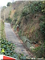
Old Chester Road above Helsby
Looking down on the Old Chester Road from a high bridge that carries a rough track and footpath. Sandstone bedrock can be seen at the side of the road.
Image: © John S Turner
Taken: 3 Apr 2009
0.17 miles
8
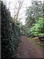
Old path above Helsby
This old path links the high level Alvanley Road with Chester Road and the village of Helsby below.
Image: © John S Turner
Taken: 3 Apr 2009
0.17 miles
9
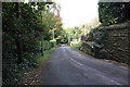
Alvanley Road, Helsby
Alvanley Road as it heads down towards the village.
Image: © Jeff Buck
Taken: 4 Oct 2012
0.20 miles
10
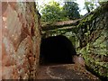
The Tunnel, Mountskill Quarry
Mountskill (Helsby) Quarry was an important source of employment in the village in the 19th century and until the 1920s. It had its own tramway link to Ince Pier whence the rock was shipped by barge to Liverpool - and used in many of the city's great buildings. It is now a Nature Reserve (with public access) and the main path from the village up through the quarry to Helsby Hill passes through this curved tunnel (seen here from the uphill side).
Image: © Mike Harris
Taken: 27 May 2006
0.21 miles