IMAGES TAKEN NEAR TO
Vale Gardens, FRODSHAM, WA6 0BT
Introduction
This page details the photographs taken nearby to Vale Gardens, WA6 0BT by members of the Geograph project.
The Geograph project started in 2005 with the aim of publishing, organising and preserving representative images for every square kilometre of Great Britain, Ireland and the Isle of Man.

There are currently over 7.5m images from over14,400 individuals and you can help contribute to the project by visiting https://www.geograph.org.uk
Image Map
Images are licensed for reuse under creativecommons.org/licenses/by-sa/2.0
Notes
- Clicking on the map will re-center to the selected point.
- The higher the marker number, the further away the image location is from the centre of the postcode.
Image Listing (69 Images Found)
Images are licensed for reuse under creativecommons.org/licenses/by-sa/2.0
Image
Details
Distance
1
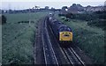
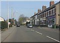
Tanks for Stanlow
The Warrington to Stanlow trip freight approaches Helsby station and the Junction . There were some nice vintage signals there in those days. No more tank trains to Stanlow as it ceased sending out traffic several years ago by rail.
Image: © roger geach
Taken: Unknown
0.05 miles
2
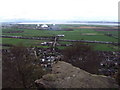
View from the top of Helsby Hill
This view is looking down the Mersey from the top of Helsby Hill with the Wirral on the left and Liverpool to the right. Helsby is below with the M56 cutting across the middle of the picture.
Image: © Tom Stapledon
Taken: 3 Apr 2011
0.05 miles
3
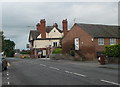
Railway Inn, Helsby
The only one of three pubs in Helsby which remains open. On the main A56 Chester Road through the middle of the town.
Image: © Eirian Evans
Taken: 7 Aug 2010
0.07 miles
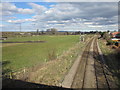
4
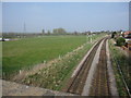
Farmland and the railway line to Warrington
A view across the farmland next to the railway line near Helsby Station.
Image: © John S Turner
Taken: 3 Apr 2009
0.07 miles
6
Meadow Farm and the railway line to Warrington
The view from Lower Rake Lane bridge over the railway line to Warrington, with Meadow Farm on the left. Apart from the light and clouds nothing much has changed since my 2009 photo Image
Image: © John S Turner
Taken: 12 Mar 2013
0.09 miles
7
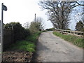
Lower Rake Lane, Helsby
Here Lower Rake Lane becomes a 'Restricted Byway' as it heads out towards Helsby Marsh over the railway bridge.
Image: © John S Turner
Taken: 3 Apr 2009
0.09 miles
8
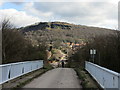
Lower Rake Lane towards Helsby Hill
Photographed from the bridge over the M56, Lower Rake Lane heads directly towards Helsby Hill in the sun.
Image: © John S Turner
Taken: 12 Mar 2013
0.10 miles
9
Lower Rake Lane and Helsby Hill
Looking across Lower Rake Lane railway bridge with the wooded slopes of Helsby Hill in the background.
Image: © John S Turner
Taken: 12 Mar 2013
0.10 miles
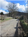
10
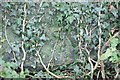
Helsby, Lower Rake Lane bridge
OS cut mark becoming hidden by ivy growth
Image: © Chris Cursley
Taken: 10 Dec 2016
0.10 miles