IMAGES TAKEN NEAR TO
Newbridge Close, WARRINGTON, WA5 9EA
Introduction
This page details the photographs taken nearby to Newbridge Close, WA5 9EA by members of the Geograph project.
The Geograph project started in 2005 with the aim of publishing, organising and preserving representative images for every square kilometre of Great Britain, Ireland and the Isle of Man.

There are currently over 7.5m images from over14,400 individuals and you can help contribute to the project by visiting https://www.geograph.org.uk
Image Map
Images are licensed for reuse under creativecommons.org/licenses/by-sa/2.0
Notes
- Clicking on the map will re-center to the selected point.
- The higher the marker number, the further away the image location is from the centre of the postcode.
Image Listing (5 Images Found)
Images are licensed for reuse under creativecommons.org/licenses/by-sa/2.0
Image
Details
Distance
1
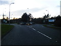
Callands Road/Cromwell Avenue roundabout
Image: © Colin Pyle
Taken: 21 Jan 2012
0.16 miles
2
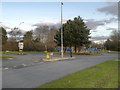
Westbrook Crescent/Cromwell Avenue Junction
Image: © David Dixon
Taken: 2 Feb 2013
0.17 miles
3
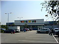
Toyshop!
Located on the Gemini Retail Park, Warrington.
Image: © Keith Williamson
Taken: 4 Jun 2007
0.19 miles
5

Gall on willow
Gall on willow leaf, made by a sawfly (Tenthredinidae family).
Image: © Keith Williamson
Taken: 4 Jun 2007
0.25 miles