IMAGES TAKEN NEAR TO
Westbrook Centre, WARRINGTON, WA5 8UD
Introduction
This page details the photographs taken nearby to Westbrook Centre, WA5 8UD by members of the Geograph project.
The Geograph project started in 2005 with the aim of publishing, organising and preserving representative images for every square kilometre of Great Britain, Ireland and the Isle of Man.

There are currently over 7.5m images from over14,400 individuals and you can help contribute to the project by visiting https://www.geograph.org.uk
Image Map (Loading...)


Getting Data...Please wait
Leaflet Map data © OpenStreetMap
Images are licensed for reuse under creativecommons.org/licenses/by-sa/2.0
Notes
- Clicking on the map will re-center to the selected point.
- The higher the marker number, the further away the image location is from the centre of the postcode.
Image Listing (9 Images Found)
Images are licensed for reuse under creativecommons.org/licenses/by-sa/2.0
Image
Details
Distance
1
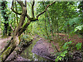
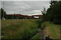
Stream in Mary Ann Plantation
Mary Ann Plantation is a 10-acre strip of mature broadleaf woodland with some newer planting, in Westbrook, in the north-west Warrington. The site is part of the Mersey Forest, an expanding network of woodlands across Merseyside and North Cheshire. The eastern section of the plantation falls within a local Site of Importance for Nature Conservation (http://www.woodlandtrust.org.uk/visiting-woods/wood-information/mary-ann-plantation/ Woodland Trust ).
Image: © David Dixon
Taken: 6 Jul 2019
0.16 miles
2
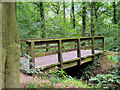
Bridge over Stream in Mary Ann Plantation
Mary Ann Plantation is a 10-acre strip of mature broadleaf woodland with some newer planting, in Westbrook, in the north-west Warrington. The site is part of the Mersey Forest, an expanding network of woodlands across Merseyside and North Cheshire. The eastern section of the plantation falls within a local Site of Importance for Nature Conservation (http://www.woodlandtrust.org.uk/visiting-woods/wood-information/mary-ann-plantation/ Woodland Trust).
Image: © David Dixon
Taken: 6 Jul 2019
0.17 miles
4

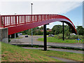
Footbridge at sunset, Westbrook, Warrington
The footbridge over Cromwell Avenue.
Image: © Matt Harrop
Taken: 9 Mar 2015
0.19 miles
5
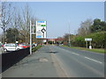
Footbridge in Kingswood
This footbridge, in the district of Kingswood Warrington, spans the centre of the traffic island at the junction of Westbrook Way and Westbrook Crescent.
Image: © Paul Anderson
Taken: 28 Jul 2007
0.20 miles
8
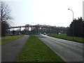
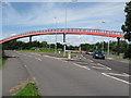
Foot Bridge over A574, Westbrook, Warrington
This foot bridge forms a large cross (as can be seen on the map) and the centre forms a roundabout on the A574, adjacent to Asda.
Image: © andy
Taken: 25 Jun 2005
0.24 miles