IMAGES TAKEN NEAR TO
New Hampshire Close, WARRINGTON, WA5 8DD
Introduction
This page details the photographs taken nearby to New Hampshire Close, WA5 8DD by members of the Geograph project.
The Geograph project started in 2005 with the aim of publishing, organising and preserving representative images for every square kilometre of Great Britain, Ireland and the Isle of Man.

There are currently over 7.5m images from over14,400 individuals and you can help contribute to the project by visiting https://www.geograph.org.uk
Image Map
Images are licensed for reuse under creativecommons.org/licenses/by-sa/2.0
Notes
- Clicking on the map will re-center to the selected point.
- The higher the marker number, the further away the image location is from the centre of the postcode.
Image Listing (11 Images Found)
Images are licensed for reuse under creativecommons.org/licenses/by-sa/2.0
Image
Details
Distance
1
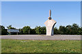
Propeller Sculpture at Dakota Park
Dakota Park, on the Chapelford Estate, was opened on Diamond Jubilee weekend in June 2012.
Image: © David Dixon
Taken: 6 Jul 2019
0.09 miles
2
Dakota in the clouds
Imaginative children's climbing frame in Dakota Park, Chapelford (on site of RAF Burtonwood)
Image: © S Parish
Taken: 23 May 2019
0.09 miles
3
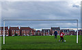
Dakota Park Kickabout
A cold Sunday afternoon kickabout on Dakota Park which was opened in 2012 and commemorates the US Air Force base at nearby Burtonwood.
Image: © Matt Harrop
Taken: 2 Dec 2018
0.11 miles
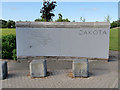
4

Dakota Park, Great Sankey
Dakota Park, on the Chapelford Estate, was opened on Diamond Jubilee weekend in June 2012.
Image: © David Dixon
Taken: 6 Jul 2019
0.12 miles
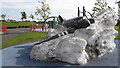
5
Dakota at Dakota Park
Dakota Park, on the Chapelford Estate, was opened on Diamond Jubilee weekend in June 2012. The entrance to the park has a relief sculpture of a USAF Dakota aircraft.
Image: © David Dixon
Taken: 6 Jul 2019
0.12 miles
6
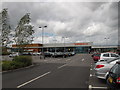
Superstore, Chapelford Urban Village, Great Sankey
This Sainsbury's is part of a new development on land tat was R.A.F. Burtonwood - see Image
Image: © David Hawgood
Taken: 22 Jun 2013
0.18 miles
7
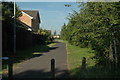
Great Sankey
This is a footpath that runs between the housing estate that I live on and what was part of the old R.A.F. Burtonwood Air Base. At my back runs Burtonwood Road and I'm looking a couple of degrees north of east.
Image: © andy
Taken: 23 Jun 2005
0.19 miles
8
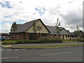
Chapelford Farm pub restaurant, Great Sankey
We had a family lunch in this pub restaurant in a new urban village development - This area was R.A.F. Burtonwood - see Image Good value, huge portions with containers supplied for taking away what you couldn't eat at the time, children's area with a "parent cam" display into the restaurant. Most of us chose the carvery, others curries or steaks.
Image: © David Hawgood
Taken: 22 Jun 2013
0.22 miles
10
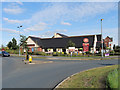
Chapelford Farm, Great Sankey
Modern public house and carvery/restaurant on the Chapelford Estate.
Image: © David Dixon
Taken: 6 Jul 2019
0.23 miles