IMAGES TAKEN NEAR TO
Kilshaw Road, WARRINGTON, WA5 4QA
Introduction
This page details the photographs taken nearby to Kilshaw Road, WA5 4QA by members of the Geograph project.
The Geograph project started in 2005 with the aim of publishing, organising and preserving representative images for every square kilometre of Great Britain, Ireland and the Isle of Man.

There are currently over 7.5m images from over14,400 individuals and you can help contribute to the project by visiting https://www.geograph.org.uk
Image Map (Loading...)


Getting Data...Please wait
Leaflet Map data © OpenStreetMap
Images are licensed for reuse under creativecommons.org/licenses/by-sa/2.0
Notes
- Clicking on the map will re-center to the selected point.
- The higher the marker number, the further away the image location is from the centre of the postcode.
Image Listing (21 Images Found)
Images are licensed for reuse under creativecommons.org/licenses/by-sa/2.0
Image
Details
Distance
3
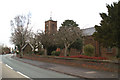
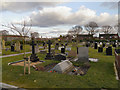
St. Michael and All Angels Chapel, Burtonwood
This is Saint Michael and All Angels Chapel along Chapel Lane, Burtonwood.
Image: © andy
Taken: 17 Jul 2005
0.14 miles
6
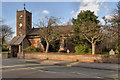
St Michael & All Angels Church, Burtonwood
St Michael's, the Parish Church of Burtonwood and Collins Green, is a Grade II listed building (http://www.britishlistedbuildings.co.uk/en-405597-church-of-st-michael-and-all-angels-burt British Listed Buildings).
The Chapel of Burtonwood was founded in 1605. The present building was erected about 1716. Some of the old oak beams of the old oak beams from the original Chapel were incorporated in the gallery of the Church, but because of decay the gallery was taken down in 1939, when the entire building was restored and enlarged.
Image: © David Dixon
Taken: 2 Feb 2013
0.14 miles
7
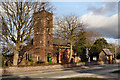
St. Michael's Church, Burtonwood
St Michael & All Angels, Parish Church of Burtonwood and Collins Green, is a Grade II listed building (http://www.britishlistedbuildings.co.uk/en-405597-church-of-st-michael-and-all-angels-burt British Listed Buildings) .
The Chapel of Burtonwood was founded in 1605. The present building was erected about 1716. Some of the old oak beams of the old oak beams from the original Chapel were incorporated in the gallery of the Church, but because of decay the gallery was taken down in 1939, when the entire building was restored and enlarged.
Image: © David Dixon
Taken: 2 Feb 2013
0.15 miles
8
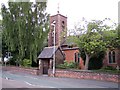
St Michael's parish church of Burtonwood
Image: © Raymond Knapman
Taken: 23 Jul 2010
0.15 miles
10
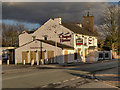
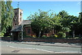
Chapel House
The Chapel House, a (recently closed) public house in Burtonwood village. Image] taken in 2010 shows the pub whilst it was still open. The tower behind belongs to St Michael's Church (Image]).
Image: © David Dixon
Taken: 2 Feb 2013
0.17 miles