IMAGES TAKEN NEAR TO
Fir Tree Lane, WARRINGTON, WA5 4NE
Introduction
This page details the photographs taken nearby to Fir Tree Lane, WA5 4NE by members of the Geograph project.
The Geograph project started in 2005 with the aim of publishing, organising and preserving representative images for every square kilometre of Great Britain, Ireland and the Isle of Man.

There are currently over 7.5m images from over14,400 individuals and you can help contribute to the project by visiting https://www.geograph.org.uk
Image Map
Images are licensed for reuse under creativecommons.org/licenses/by-sa/2.0
Notes
- Clicking on the map will re-center to the selected point.
- The higher the marker number, the further away the image location is from the centre of the postcode.
Image Listing (12 Images Found)
Images are licensed for reuse under creativecommons.org/licenses/by-sa/2.0
Image
Details
Distance
1
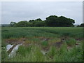
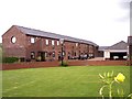
Farmland and woodland, Boarded Barn Farm
East of Fir Tree Lane.
Image: © JThomas
Taken: 5 Jun 2014
0.04 miles
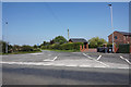
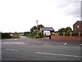
3
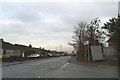
Junction of Alder Lane with Fir Tree Lane
Image: © David Long
Taken: 18 Jan 2010
0.06 miles
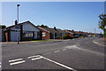
4
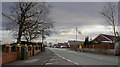
A bus stop in Burtonwood by Boarded Barn Farm
Image: © Ian Greig
Taken: 25 Feb 2012
0.07 miles
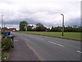
5
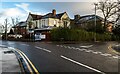
Buildings
Buildings at the junction of Alder Lane with Fir Tree Lane.
Image: © Peter McDermott
Taken: 3 Jan 2021
0.07 miles
7
Barn conversion at Boarded Barn Farm
Image: © Raymond Knapman
Taken: 23 Jul 2010
0.12 miles
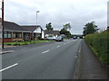
8
Junction of Hall Lane and Fir Tree lane
Image: © Raymond Knapman
Taken: 23 Jul 2010
0.13 miles