IMAGES TAKEN NEAR TO
Jackson Street, WARRINGTON, WA5 4HN
Introduction
This page details the photographs taken nearby to Jackson Street, WA5 4HN by members of the Geograph project.
The Geograph project started in 2005 with the aim of publishing, organising and preserving representative images for every square kilometre of Great Britain, Ireland and the Isle of Man.

There are currently over 7.5m images from over14,400 individuals and you can help contribute to the project by visiting https://www.geograph.org.uk
Image Map (Loading...)


Getting Data...Please wait
Leaflet Map data © OpenStreetMap
Images are licensed for reuse under creativecommons.org/licenses/by-sa/2.0
Notes
- Clicking on the map will re-center to the selected point.
- The higher the marker number, the further away the image location is from the centre of the postcode.
Image Listing (26 Images Found)
Images are licensed for reuse under creativecommons.org/licenses/by-sa/2.0
Image
Details
Distance
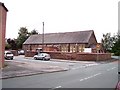
1
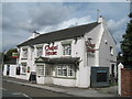
The Village Frier
The Village Frier in Burtonwood.
Image: © Peter McDermott
Taken: 3 Jan 2021
0.07 miles
3
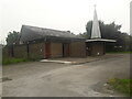
St Paul of the Cross Roman Catholic Church
Built 2001. Architects Cassidy & Ashton.
Image: © S Parish
Taken: 12 Sep 2021
0.09 miles
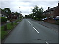
5
Village Barbers Burtonwood
This is the centre of Burtonwood on Clay Lane where the village barbers shop is located.
Image: © Paul Anderson
Taken: 28 Jul 2007
0.10 miles
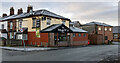
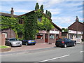
7
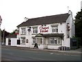
Chapel House public house Burtonwood
Image: © Raymond Knapman
Taken: 23 Jul 2010
0.11 miles