IMAGES TAKEN NEAR TO
Broad Lane, WARRINGTON, WA5 4AE
Introduction
This page details the photographs taken nearby to Broad Lane, WA5 4AE by members of the Geograph project.
The Geograph project started in 2005 with the aim of publishing, organising and preserving representative images for every square kilometre of Great Britain, Ireland and the Isle of Man.

There are currently over 7.5m images from over14,400 individuals and you can help contribute to the project by visiting https://www.geograph.org.uk
Image Map
Images are licensed for reuse under creativecommons.org/licenses/by-sa/2.0
Notes
- Clicking on the map will re-center to the selected point.
- The higher the marker number, the further away the image location is from the centre of the postcode.
Image Listing (7 Images Found)
Images are licensed for reuse under creativecommons.org/licenses/by-sa/2.0
Image
Details
Distance
2
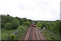
Liverpool Manchester railway crosses Bold Moss
View from Broad Lane bridge
Image: © Raymond Knapman
Taken: 13 May 2011
0.08 miles
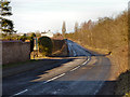
3
Broad Lane Railway Bridge
Broad Lane crossing the Liverpool to Manchester railway line.
Image: © David Dixon
Taken: 2 Feb 2013
0.10 miles
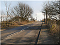
4

The view towards Billinge Hill from the 12.01 from Newton-le-Willows
Beyond the left-hand pylon may be seen the lamp standards along the A572, St Helens to Earlestown road.
Image: © David Long
Taken: 8 Oct 2009
0.22 miles
5

Moss Hall Farm
A view looking south towards Moss Hall Farm. I was on top of one of the many old slag heaps that are scattered around these parts. This particular one was created by the workings of Collins Green Colliery. In the far distance, just visible over the hill, is Fiddlers Ferry Power Station.
Image: © andy
Taken: 26 Jul 2005
0.22 miles
6
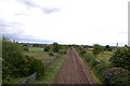
Liverpool Manchester railway viewed towards Collins Green
Image: © Raymond Knapman
Taken: 13 May 2011
0.23 miles
7

Another view towards Billinge Hill from the 12.01 from Newton-le-Willows
The houses are along the line of the road from Derbyshire Hill to Burtonwood.
Image: © David Long
Taken: 8 Oct 2009
0.23 miles