IMAGES TAKEN NEAR TO
Belvedere Drive, WARRINGTON, WA5 3SQ
Introduction
This page details the photographs taken nearby to Belvedere Drive, WA5 3SQ by members of the Geograph project.
The Geograph project started in 2005 with the aim of publishing, organising and preserving representative images for every square kilometre of Great Britain, Ireland and the Isle of Man.

There are currently over 7.5m images from over14,400 individuals and you can help contribute to the project by visiting https://www.geograph.org.uk
Image Map
Images are licensed for reuse under creativecommons.org/licenses/by-sa/2.0
Notes
- Clicking on the map will re-center to the selected point.
- The higher the marker number, the further away the image location is from the centre of the postcode.
Image Listing (20 Images Found)
Images are licensed for reuse under creativecommons.org/licenses/by-sa/2.0
Image
Details
Distance
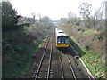
2
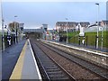
Warrington West railway station
Opened in 2019 by Network Rail on the line from Manchester Piccadilly to Liverpool.
View west towards Sankey for Penketh and Liverpool, a few weeks after opening.
Image: © Nigel Thompson
Taken: 28 Jan 2020
0.12 miles
3
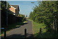
Great Sankey
This is a footpath that runs between the housing estate that I live on and what was part of the old R.A.F. Burtonwood Air Base. At my back runs Burtonwood Road and I'm looking a couple of degrees north of east.
Image: © andy
Taken: 23 Jun 2005
0.12 miles
5
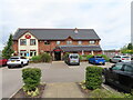
Chapelford Farm, farmhouse inn, Warrington
It is on the area of the former USAF airfield. See Image for another view, 9 years before.
Image: © David Hawgood
Taken: 26 Jun 2022
0.15 miles
6
Warrington West station
The recently opened station in Great Sankey - taken in January 2020 about a month after opening
Image: © Linda Broadbent
Taken: 19 Jan 2020
0.16 miles
8
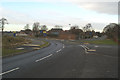
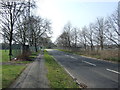
Burtonwood Road, much altered
The map still shows a Level Crossing where the roundabout is. This carried the line serving the US Base at RAF Burtonwood. A new road, veering left takes its place. The main road to the base, Burtonwood Road is now intersected at several points and is no longer a through road. The entrance to the Burtonwood Repair Depot was beyond the tree on the right, with the base's main gates being a few hundred yards north. Housing is increasingly covering the site.
Image: © David Long
Taken: 2 Jan 2009
0.16 miles
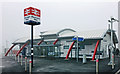
9
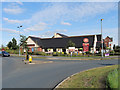
Chapelford Farm, Great Sankey
Modern public house and carvery/restaurant on the Chapelford Estate.
Image: © David Dixon
Taken: 6 Jul 2019
0.17 miles
10
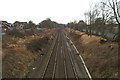
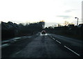
Cheshire Lines Committee Liverpool-Manchester line, looking West
The US Base of RAF Burtonwood once occupied the land to the right, with a housing area, known as the 'Tobacco Houses' opposite the thicket of trees on the left.
Image: © David Long
Taken: 2 Jan 2009
0.17 miles