IMAGES TAKEN NEAR TO
Stocks Lane, WARRINGTON, WA5 2RJ
Introduction
This page details the photographs taken nearby to Stocks Lane, WA5 2RJ by members of the Geograph project.
The Geograph project started in 2005 with the aim of publishing, organising and preserving representative images for every square kilometre of Great Britain, Ireland and the Isle of Man.

There are currently over 7.5m images from over14,400 individuals and you can help contribute to the project by visiting https://www.geograph.org.uk
Image Map
Images are licensed for reuse under creativecommons.org/licenses/by-sa/2.0
Notes
- Clicking on the map will re-center to the selected point.
- The higher the marker number, the further away the image location is from the centre of the postcode.
Image Listing (9 Images Found)
Images are licensed for reuse under creativecommons.org/licenses/by-sa/2.0
Image
Details
Distance
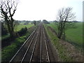
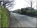
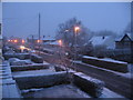
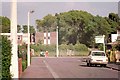
2
Lull In The Traffic Penketh
Looking South towards Stocks Lane Bridge over the Liverpool to Manchester railway line.
Image: © Brian Balfe
Taken: 28 Apr 2009
0.08 miles
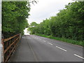
5
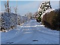
Friends Lane,Great Sankey
Snow scene of Friends Lane from the junction with Stocks Lane taken in January 2010.
Image: © Brian Balfe
Taken: 6 Jan 2010
0.19 miles
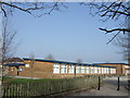
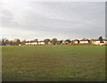
8
Edward Road, Great Sankey, 1974
The building on the far side of the field at the end of this quiet cul-de-sac is Greystone Heath, a residential school owned by Liverpool City Council. It has since closed and been demolished.
Image: © Chris Denny
Taken: Unknown
0.22 miles