IMAGES TAKEN NEAR TO
Ditchfield Road, WARRINGTON, WA5 2NN
Introduction
This page details the photographs taken nearby to Ditchfield Road, WA5 2NN by members of the Geograph project.
The Geograph project started in 2005 with the aim of publishing, organising and preserving representative images for every square kilometre of Great Britain, Ireland and the Isle of Man.

There are currently over 7.5m images from over14,400 individuals and you can help contribute to the project by visiting https://www.geograph.org.uk
Image Map
Images are licensed for reuse under creativecommons.org/licenses/by-sa/2.0
Notes
- Clicking on the map will re-center to the selected point.
- The higher the marker number, the further away the image location is from the centre of the postcode.
Image Listing (17 Images Found)
Images are licensed for reuse under creativecommons.org/licenses/by-sa/2.0
Image
Details
Distance
1
Station Rd Penketh
Looking towards the St Helens,Widnes canal and the River Mersey
Image: © Brian Balfe
Taken: 2 Feb 2009
0.18 miles
2
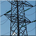
Birds among the pylons, Penketh
Nestling high up on the pylons linking Penketh to Warrington and Widnes, these birds are basking in the evening sun.
Image: © Matt Harrop
Taken: 10 Sep 2016
0.18 miles
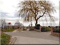
3
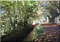
Well Lane
Falling leaves and autumn sunshine on Well Lane.
Image: © Brian Balfe
Taken: 25 Oct 2010
0.19 miles
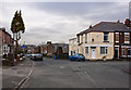
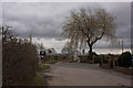
5
Station Road Penketh
Station Road Penketh, looking North East.
Image: © Brian Balfe
Taken: 2 Feb 2009
0.22 miles
6
Level Crossing, Station Road
Between 1856 and 1950, there was a railway station on the right which enabled day-trippers to come here to watch the boats and the river, and visit the nearby Ferry Tavern (Image]).
Image: © David Dixon
Taken: 23 Apr 2013
0.22 miles
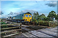
8

Railway Crossing, Fiddler's Ferry, Penketh at dusk
The crossing, outside the old Station House is brightly illuminated, casting long shadows on the approach. the only trains that use this stretch are those serving the Fiddler's Ferry Power Station.
Image: © Matt Harrop
Taken: 3 Oct 2016
0.23 miles
9
Railway Crossing, Fiddler's Ferry, Penketh
A train carrying fuel for the Fiddler's Ferry Power Station passes the crossing close to the Ferry Tavern, Penketh.
Image: © Matt Harrop
Taken: 30 Sep 2016
0.23 miles
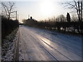
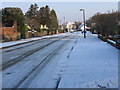
10
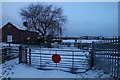
Railway crossing at dawn with snow
Fiddlers Ferry rail crossing looking north-west toward Station Rd. The line is used to transport coal and waste to/from Fiddler's Ferry Power Station.
Image: © Matt Harrop
Taken: 30 Jan 2015
0.23 miles