IMAGES TAKEN NEAR TO
Lytham Close, WARRINGTON, WA5 2GH
Introduction
This page details the photographs taken nearby to Lytham Close, WA5 2GH by members of the Geograph project.
The Geograph project started in 2005 with the aim of publishing, organising and preserving representative images for every square kilometre of Great Britain, Ireland and the Isle of Man.

There are currently over 7.5m images from over14,400 individuals and you can help contribute to the project by visiting https://www.geograph.org.uk
Image Map
Images are licensed for reuse under creativecommons.org/licenses/by-sa/2.0
Notes
- Clicking on the map will re-center to the selected point.
- The higher the marker number, the further away the image location is from the centre of the postcode.
Image Listing (12 Images Found)
Images are licensed for reuse under creativecommons.org/licenses/by-sa/2.0
Image
Details
Distance
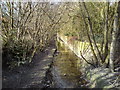
4

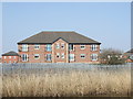
St Helens Canal
Housing alongside the disused St Helens Canal.
Image: © Peter McDermott
Taken: 3 Jan 2021
0.06 miles
5

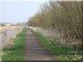
Trans Pennine Trail Along St Helens Canal
Image: © Richard Cooke
Taken: 23 Mar 2020
0.11 miles
6

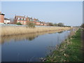
Sankey St.Helens Canal
This is a view looking WSW down the Sankey St.Helens Canal. This canal used to be busy with fishermen throughout the year but are no longer allowed to fish here due to an unstable canal wall. The canal is now becoming over run with weed and algae. The Trans Pennine Trail runs along here and Fiddlers Ferry Power Station can be seen in the distance.
Image: © andy
Taken: 20 Aug 2005
0.13 miles
7

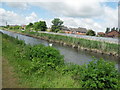
Sankey St.Helens Canal
This is a rather sad looking section of the disused Sankey St.Helens Canal. Warrington Borough Council have decided to fence off the tow path rather than trying to make it safe enough for anglers to use this stretch. As you can see, the canal itself is becoming clogged up with weed and algae since the anglers have been kept away.
Image: © andy
Taken: 20 Aug 2005
0.19 miles
9
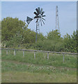
Renewable Energy and Fossil Fuel
A wind pump supplies electricity in small quantities for a specific, local job whilst the pylon in the background carries electricity generated from the burning of fossil fuel at Fiddler's Ferry power station nearby.
Taken looking north from SJ575871
Image: © Gary Rogers
Taken: 12 May 2005
0.22 miles
10
Whittle Brook
Looking upstream. Whittle Brook marks the boundary between Penketh and Great Sankey, Warrington. It is a tributary of the River Mersey which it joins just south of this point. Photograph taken from the Penketh Road/A562 bridge which crosses the brook here.
Image: © Keith Williamson
Taken: 10 Mar 2010
0.25 miles