IMAGES TAKEN NEAR TO
Mapplewell Crescent, WARRINGTON, WA5 1UT
Introduction
This page details the photographs taken nearby to Mapplewell Crescent, WA5 1UT by members of the Geograph project.
The Geograph project started in 2005 with the aim of publishing, organising and preserving representative images for every square kilometre of Great Britain, Ireland and the Isle of Man.

There are currently over 7.5m images from over14,400 individuals and you can help contribute to the project by visiting https://www.geograph.org.uk
Image Map
Images are licensed for reuse under creativecommons.org/licenses/by-sa/2.0
Notes
- Clicking on the map will re-center to the selected point.
- The higher the marker number, the further away the image location is from the centre of the postcode.
Image Listing (6 Images Found)
Images are licensed for reuse under creativecommons.org/licenses/by-sa/2.0
Image
Details
Distance
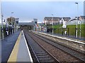
3

Warrington West station
The recently opened station in Great Sankey - taken in January 2020 about a month after opening
Image: © Linda Broadbent
Taken: 19 Jan 2020
0.11 miles
5
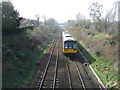
Warrington West railway station
Opened in 2019 by Network Rail on the line from Manchester Piccadilly to Liverpool.
View west towards Sankey for Penketh and Liverpool, a few weeks after opening.
Image: © Nigel Thompson
Taken: 28 Jan 2020
0.15 miles